
This time last week, we came to the end of our epic road trip around England and Wales. Over 13 days, we travelled from London to the Jurassic Coast, through Devon, Somerset, South Wales, Mid Wales, North Wales and Shropshire, visiting sites that tell the story of almost the entire geological timescale.
England and Wales are among the most geodiverse places on Earth. Across a relatively small area, it is possible to see rocks from nearly every Phanerozoic geological period, from ancient Precambrian rocks to the landscapes shaped during the Ice Age. This is also the region where so much of geological science was developed, with the Cambrian, Ordovician, Silurian, Devonian and Carboniferous all having type areas here.
Our guests were treated to an incredible variety of sites and experiences: fossils on the Jurassic Coast, granite tors on Dartmoor, caves and unconformities in Somerset, coal mines and industrial history in South Wales, trilobites in Mid Wales, ancient copper mines and slate landscapes in North Wales, and the history of geology in Shropshire.
It was a wonderful reminder of just how geologically rich England and Wales really are.
We visited World Heritage Sites, UNESCO Global Geoparks, National Parks, fossil beaches, mines, museums, mountain landscapes and some of the most important sites in the history of geology. There were far too many highlights to show them all, so we have chosen 60 captioned photos to share a flavour of this remarkable tour.
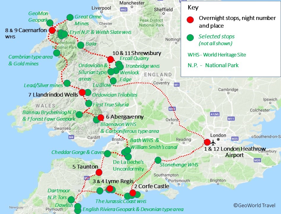
Route map of GeoWorld Travel’s ‘The Trilobites Sahara Kingdom’ tour
Day One: Arrival in London
The group met near Heathrow ahead of the journey, ready to begin 13 days of geology, landscapes and deep time.
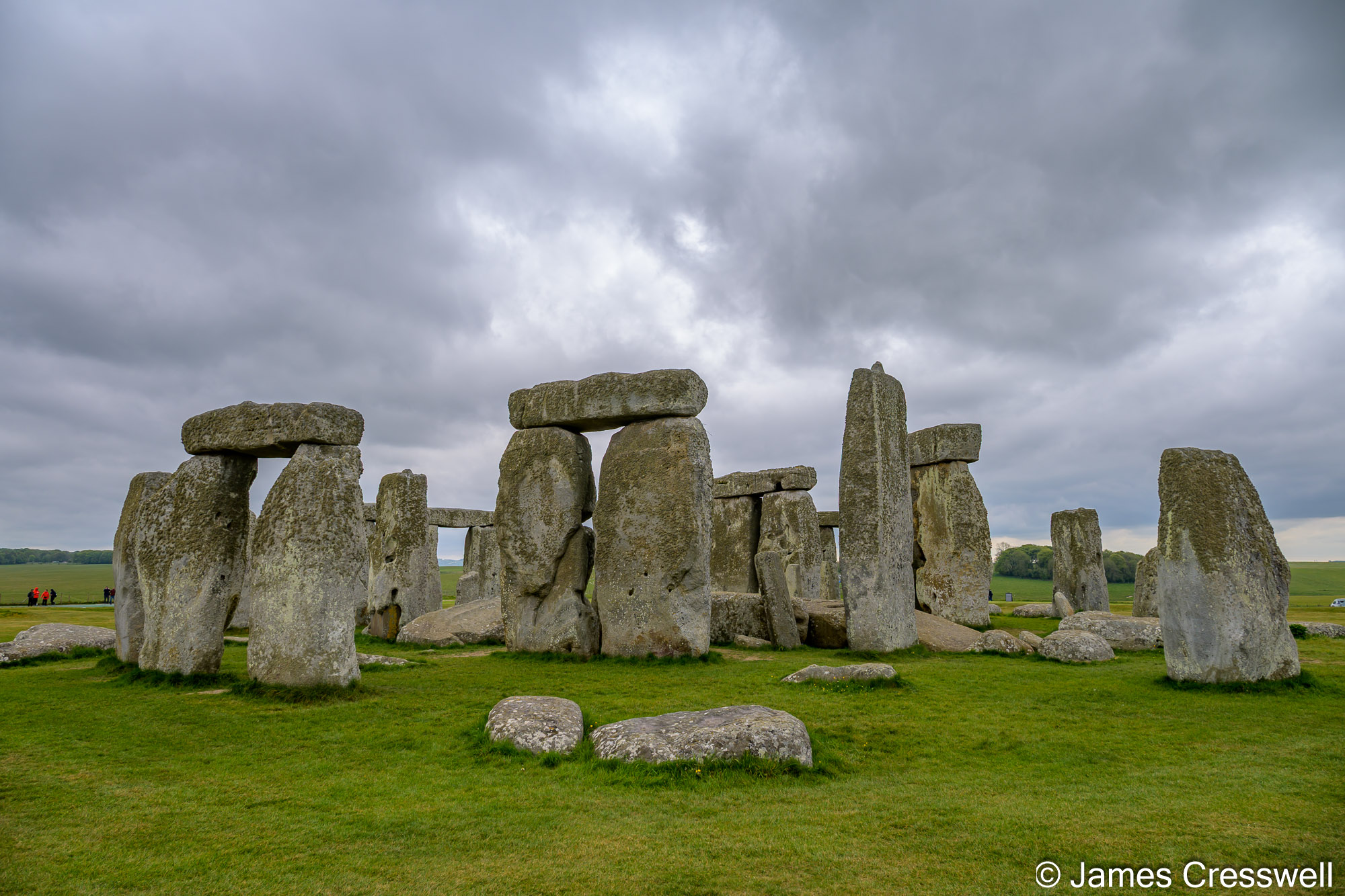
Day Two: Stonehenge and the Isle of Purbeck
We began with Stonehenge World Heritage Site before heading to the Jurassic Coast, including The Etches Collection and the fossil rich rocks of Kimmeridge.
Left: Our England & Wales tour starts at Stonehenge. Although a world-famous archaeological site, there is also significant geological interest here. The Sarsen stones, the outer circle, are composed of hard siliceous Paleogene sandstones (silcretes) and were derived relatively locally. The silcretes were deposited as sands in the Paleogene and were further silicified during the Neogene and Quaternary by weathering. The Sarsen stones are the post glacial remains of a cap of silcretes that once covered much of southern England and make very convenient building stones for monuments. The bluestone assemblages, found inside the outer circle, are igneous rocks typically weighing 2-3 tonnes. They are predominantly low-grade metamorphosed dolerites and rhyolitic tuffaceous rocks. Recent petrological and geochemical investigations have identified the source for some of the rhyolitic bluestone material as Craig Rhos-y-felin, in the Preseli Hills of West Wales. This raises the challenging question of how the stones arrived in Wiltshire from West Wales. Traditionally the Altar Stone has been considered one of the bluestones, but it has more recently been demonstrated to be a sandstone, specifically an Old Red Sandstone.
Top right: The GeoWorld Travel group enjoy an explanation of an ichthyosaur fossil by the finder, Steve Etches at the museum he founded, The Etches Collection. The museum is based on Steve’s lifetime collection and all the specimens come from the Kimmeridge area. The Kimmeridge Clay of Kimmeridge Bay has produced many specimens of turtles, crocodiles, pterosaurs, plesiosaurs, ichthyosaurs and dinosaurs, including several type specimens. These include some giant crocodiles (Dacosaurus maximus), plesiosaurs (Pliosaurus ferox) and dinosaurs (Cetiosaurus).
Bottom right: The famous ‘Sea Rex’, an incredible Pliosaur skull which was featured in the BBC documentary ‘Attenborough and the Giant Sea Monster’. The body of the Pliosaur remains in the cliff where the skull was found and a funding campaign is underway to raise funds to complete the excavation of this amazing specimen. The Pliosaur would have lived in the seas of Kimmeridge around 150 million years ago. It is also a Guinness World Record holder: the most complete Pliosaur skull in existence!
Left: Steve Etches with the GeoWorld Travel group at The Etches Collection, Kimmeridge.
Right: An oil well on the cliff above Kimmeridge Beach. It pumps oil from the Kimmeridge Clay, which is a Kimmeridgian-aged (latest Jurassic), sedimentary deposit of fossiliferous marine clay that occurs in southern and eastern England and in the North Sea. This rock formation is the major source rock for North Sea oil.
Left: Steven & Wilma examine a harder layer of limestone within the Kimmeridge Formation. The Kimmeridge Formation has alternating layers of shale and limestone which may reflect seasonal deposition changes caused by Milankovitch cycles.
Right: The GeoWorld Travel group examine sauropod dinosaur footprints at Spyway (Keates) Quarry on the Jurassic Coast. The 140-million-year-old (earliest Cretaceous) footprints are found in Purbeck limestone.
Left: A view of Durdle Door, which is one of the Jurassic Coast’s most iconic landforms. It is a natural arch through vertical beds of Portland Limestone (latest Jurassic). The strata are vertical on the Isle of Purbeck because they are part of a monocline that formed in the Pyrenean orogeny of the Palaeocene (~60 Ma) epoch of the Paleogene.
Right: A view of Lulworth Cove, which is a small, almost circular bay with a narrow opening to the sea. Along with the adjacent cliffs and bays, it is often regarded as the best example in Europe of the interaction of marine erosion on an alternating sequence of hard and soft rocks. The unbroken sequence from Jurassic limestones to the Cretaceous Chalk, exposed in cliffs up to 150m high, gives a continuous record of about 80 million years of the Earth’s past geography and climate.
Day Three: Lulworth Cove and Lyme Regis
From Cretaceous dinosaur tracks to the famous curves of Lulworth Cove and the ammonite pavement at Monmouth Beach, this was a classic Jurassic Coast day.
Left: The Lulworth Crumple, at Stair Hole, near Lulworth Cove. This feature shows folded (crumpled) layers of Purbeck limestone resting on less folded layers of Portland Stone (to the right of the image). The Portland layers are folded because they lie very close to the Purbeck Fault; this is a Variscan-aged fault that has been reactivated multiple times, including, most recently, in the Pyrenean Orogeny approximately 60 million years ago.
Middle: Lyme Regis palaeontologist, Chris Andrew, shows a Lyme Regis nautilus, which has been cut in half, during his talk to our group about local fossils.
Right: Chris Andrew shows part of an ichthyosaur paddle, which he found, against a model of the animal.
Left: The GeoWorld Travel group with Chris Andrew at the statue of Mary Anning in Lyme Regis.
Right: Chris Andrew leading the GeoWorld Travel group on a fossil walk along Lyme Regis beach. Here he is pointing out some ammonites preserved in a small area of ammonite pavement.
Left: The GeoWorld Travel group on Lyme Regis beach with a large ammonite in the foreground.
Right: A Jurassic Coast World Heritage Site information panel with the Lower Jurassic (Blue Lias) cliffs in the background.
Left: Kingston at the Sidmouth Museum, next to a display of Triassic-aged fossils found in the cliffs at Sidmouth.
Right: The cliffs at Dawlish are formed from aeolian (wind-blown) sand which was laid down in a desert in a continental interior in the Permian Period roughly 250 million years ago. The rocks are part of the New Red Sandstone.
Day Four: Fossil Hunting at Lyme Regis
A full day in one of the world’s most famous fossil locations, following in the footsteps of Mary Anning and searching the Lower Jurassic beaches.
Left: Lummaton Quarry in the English Riviera UNESCO Global Geopark. Lummaton Quarry is one of the most historically important sites in the Devonian type area of southwest England. Although now largely occupied by a trading estate, with no public access to the rock exposures, it was a key collecting site for the fossils that helped define the Devonian marine fauna. The quarry exposed reefal limestones deposited in warm, shallow tropical seas, including stromatoporoid reefs. Of particular importance are the Lummaton Shell Beds (Givetian), a unit containing an exceptionally rich shelly fauna preserved in discontinuous lenses and pockets. These fossil assemblages were central to early work by Adam Sedgwick and Roderick Murchison in characterising the Devonian System and remain among the most important Devonian fossil faunas known.
Top right: The GeoWorld Travel group at Triangle Point in the English Riviera UNESCO Global Geopark. The group are examining marine Devonian fossils in their type area of Devon. The layers of rock here are overturned due to being in a Variscan fold.
Bottom right: Nick sitting on Haytor Rocks in Dartmoor National Park. This classic site contains the best exposure of variants of the coarse, megacrystic granite of Dartmoor, together with a later, intrusive, fine-grained granite sheet. Its coarse-grained granites enclose a variety of genetically significant xenoliths. It also provides excellent evidence of tourmalinization.
Left: Replica of the Cheddar Man in the location he was discovered in Gough’s Cave, Cheddar Gorge. The cave has also yielded important archaeological remains, including evidence of Late Upper Palaeolithic occupation (~14,700 years ago) and “Cheddar Man”, Britain’s oldest complete human skeleton (~10,000 years old).
Right: The GeoWorld Travel group at the famous ‘De La Beche’ unconformity, described in the world’s first Geological Survey memoir in 1846. Here, an old quarry clearly shows the unconformity between the yellow-coloured, horizontally bedded Jurassic Inferior Oolite limestone and the underlying grey, massively bedded and steeply dipping Carboniferous Vallis Limestone.
Left: The Radstock Museum lies at the terminus of the southern branch of the Somersetshire Coal Canal. The museum contains fossils from the coal and information about William Smith ‘Father of English geology’ who discovered the principles of stratigraphy while working on the construction of the canal.
Right: A view over the city of Bath. In 1987 the City of Bath was inscribed as a World Heritage Site, and in 2021 received a second inscription as one of the Great Spa Towns of Europe. Founded by the Romans as a thermal spa, Bath became an important centre of the wool industry in the Middle Ages. In the 18th century, under George III, it developed into an elegant town with neoclassical Palladian buildings, which blend harmoniously with the Roman baths. The hot springs in Bath, rising in the centre of the city, are Britain’s best geothermal feature.
Day Five: Devonian Stories and Dartmoor Granite
We explored Triassic and Permian red beds, Devonian type area geology, fossil desert dunes at Dawlish and the granite tors of Dartmoor National Park.
Top left: A bench in the village of Gilwern on the Monmouthshire & Brecon Canal, just outside the Blaenavon Industrial Landscape World Heritage Site. Coal and iron would have been brought down from the mountains above for export from the major port of Newport to the south.
Top right: Mike, a volunteer at the Blaenavon Ironworks, explains the site rich and varies history. The scale model of the site in the foreground gives an idea of how extensive it once was. The ironworks was built in 1787 and, famously, it was the site of the successful experiment ‘The Elimination of Phosphorus in the Bessemer Converter’ in 1878.
Middle right: The GeoWorld Travel group ready to go underground at Big Pit, the National Coal Museum of Wales! The Big Pit was a working coal mine from 1880 until 1980 although originally, from around 1810, it was an iron mine. At its peak, in 1923, 1,400 people were employed there. It was opened to the public as a museum in 1983 and is dedicated to operational preservation of the Welsh heritage of coal mining.
Bottom: The Brynmawr Sections Site of Special Scientific Interest. Here, well-bedded sandstones, mudstones and ironstones of the Lower South Wales Coal Measures can be seen in situ. The seatearth floor of the Five-Feet – Gellideg Coal is the topmost bed of the main exposure.
Day Six: Cheddar, William Smith and Bath
From Gough’s Cave and Cheddar Gorge to the De La Beche Unconformity and William Smith’s geological legacy, this was a day packed with scientific history.
Left: The Ffos-y-fran Opencast in Merthyr Tydfil. The opencast exposes a substantial section through the South Wales Coal Measures (Pennsylvanian/Westphalian). The dark layers visible in the photograph are coal seams and the lighter layers are sandstones.
Right: Craig Cerrig-gleisiad, which is an L-shaped glacial cwm (cirque) in the Bannau Brycheiniog (Brecon Beacons) National Park. Its form is a result of both glacial action and rock-slope failure, a portion of the west wall having collapsed after the main part of the last ice age. The debris from the landslip (on the right of the image) reaches as far as the adjacent road.
Left: The River Wye at ‘Cavansham Ferry’ where Sir Roderick Impey Murchison recounted his encounter with greywacke rocks on his 1831 geological fieldwork tour of England & Wales. It was here that Murchison first decided that there was sufficient evidence to enable him to make a systematic study of the greywacke rocks which was to culminate in the publication of ‘The Silurian System’ in 1839, and he came to regard the site as ‘The first true Silurian’.
Top right: A piece of Silurian-aged fossiliferous rock at Llanstephan Quarry. This is the site that Murchison found after crossing Cavansham Ferry and ascending the hill.
Bottom right: The GeoWorld Travel group enjoy an evening lecture by Dr Joe Botting and Dr Lucy Muir. Their discovery of the Castle Bank Lagerstätte, a remarkable Middle Ordovician site preserving over 170 species, many with soft tissues, has provided a rare insight into ecosystems during the Great Ordovician Biodiversification Event. This internationally important geology is now recognised within the Heart of Wales Geopark, founded by Joe & Lucy, and established to promote and protect the region’s geological heritage.
Day Seven: Coal, Iron and the Brecon Beacons
In South Wales, we descended Big Pit, explored Blaenavon’s industrial landscape and saw how geology helped power the Industrial Revolution.
Top left: The GeoWorld Travel group listening to geological explanations by Dr Joe Botting at Llanfawr Quarry in the Heart of Wales Geopark. The upper part of the Llanfawr Mudstones is exposed at Llanfawr Quarry, representing the later, deeper-water phase of the volcanic island system. These black mudstones were deposited after volcanic activity had largely ceased, in a quiet marine setting, and are exceptionally fossiliferous, yielding abundant trilobites, graptolites, sponges and other marine organisms. The quarry itself was originally opened to extract dolerite intrusions that cut through the mudstones, and removal of this harder igneous rock exposed the fossil-rich shales that are now of such scientific importance.
Top right: Graptolites (middle Ordovician) found in the Llanfawr Quarry in the Heart of Wales Geopark.
Day Eight: Trilobites, Mines and the Cambrian Rocks of Wales
A real fossil hunting highlight, with Ordovician trilobites near Llandrindod Wells, metal mining landscapes and the Cambrian rocks of the Harlech Dome.
Top left: The GeoWorld Travel group at the Caban Coch Quarry in the Elan Valley examining Llandovery (early Silurian) rocks. The rocks are a conglomerate that formed in underwater landslides.
Top right: Caban Coch Dam in the Elan Valley. There is an outcrop of Llandovery (early Silurian) rock at the far end of the dam, which we also saw at our previous stop in the nearby quarry.
Middle right: A pumping mechanism at Dylife Mine. The mine was a major lead producer with some silver, copper and zinc. The first recorded working was about 1640 by Thomas Bushell although it may be much older, possibly pre-Roman, and may have been worked by the Romans sometime after 70AD.
Bottom: Galena (lead ore) in a quartz vein found at Dylife Mine.
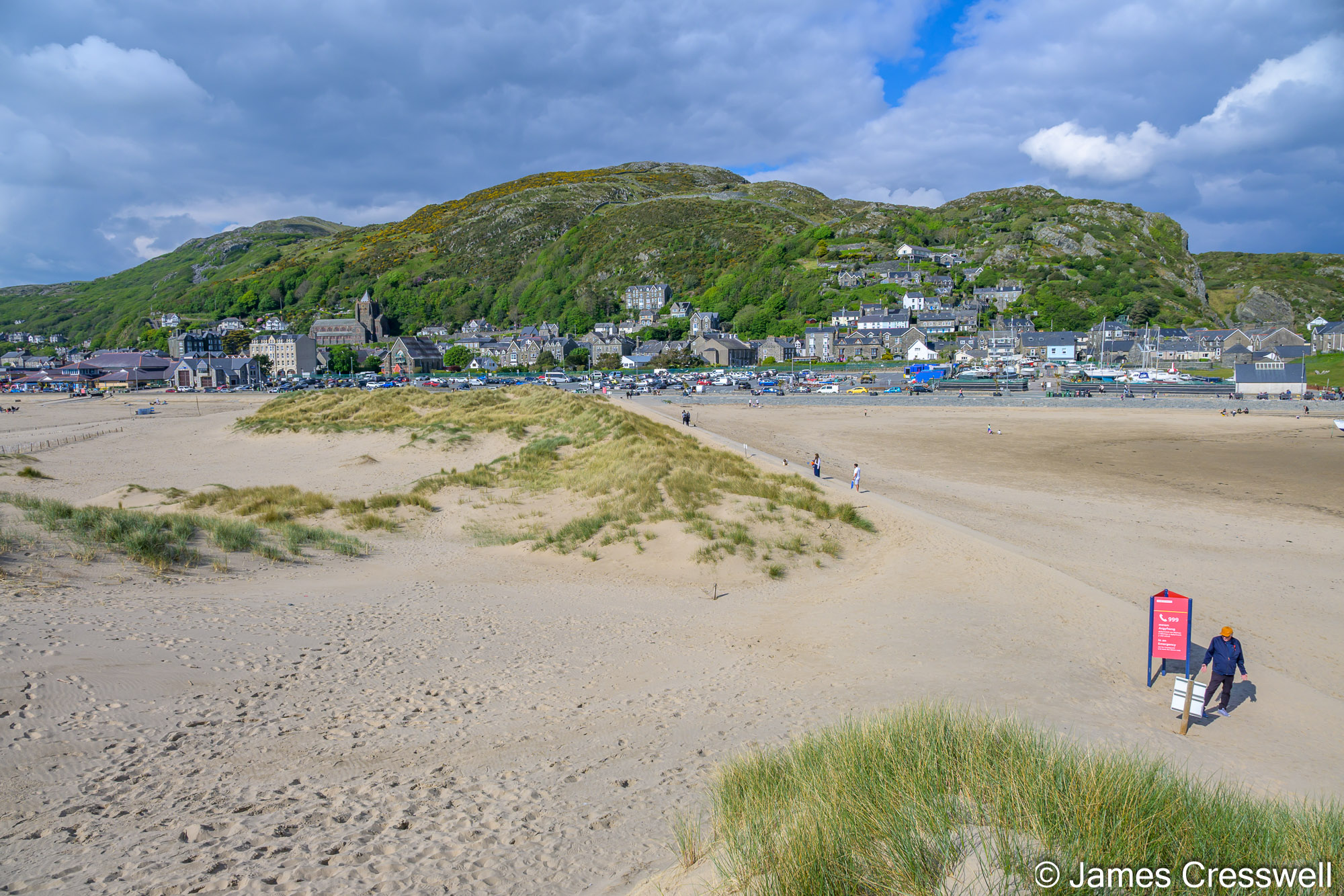
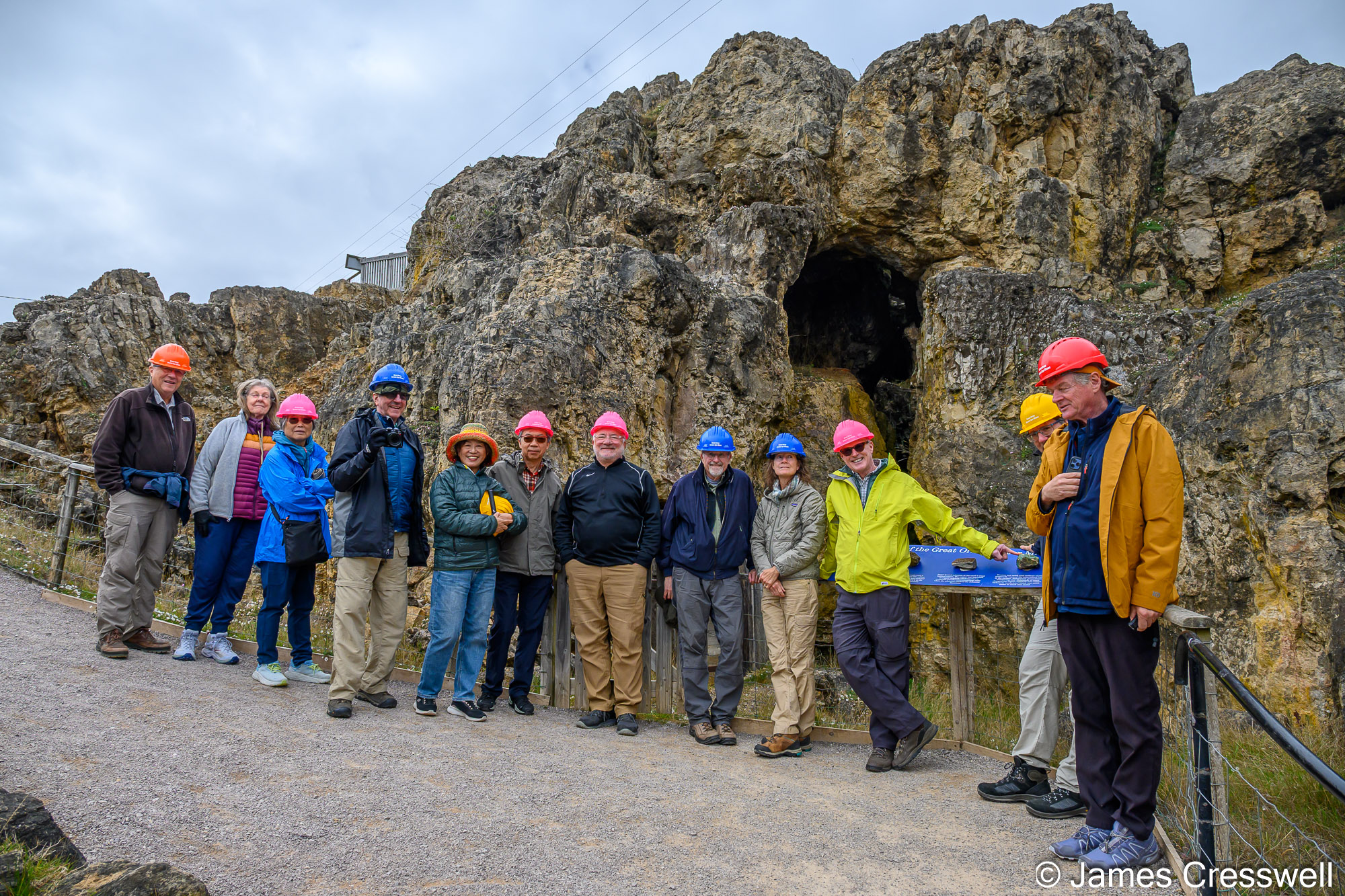
Day Nine: Great Orme, Anglesey and North Wales
We descended into the Bronze Age copper mine at Great Orme, visited GeoMôn UNESCO Global Geopark and explored some of North Wales’ remarkable geology and heritage.
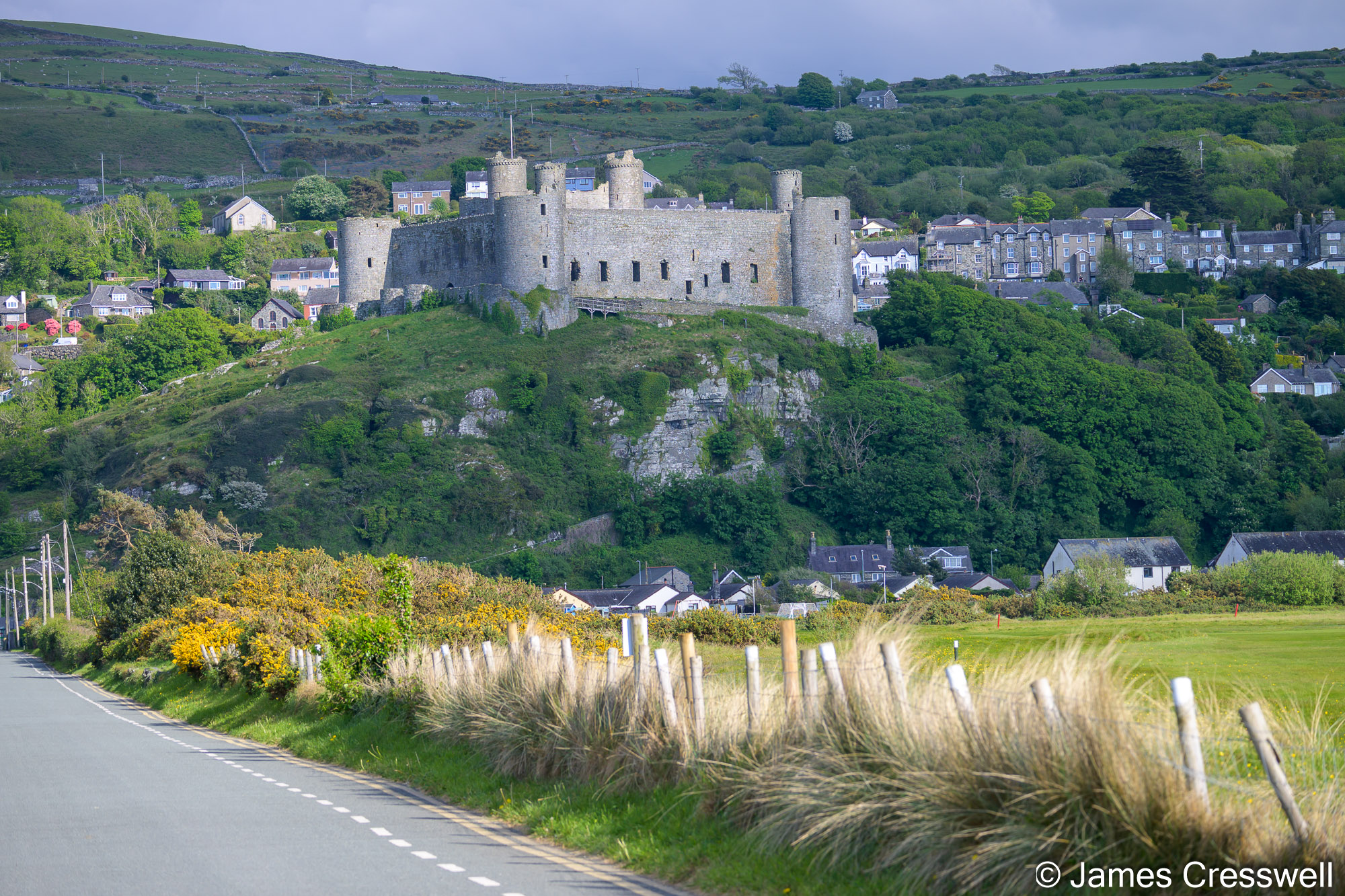
Top Left: At Barmouth a large part of the Cambrian succession can be seen, from the lower Cambrian Rhinog Formation to the upper Cambrian Maentwrog Formation. It is the core area of Sedgwick’s Cambrian System and is the largest exposed area of Cambrian rocks in Wales. It has an almost complete stratigraphical succession. The name ‘Cambrian’ comes from the Latinized name for Wales: Cambria.
Top Middle: Harlech Castle, which is part of the Castles and Town Walls of King Edward in Gwynedd World Heritage Site. The castle stands on Cambrian rock (Rhinog Formation, Comley Series).
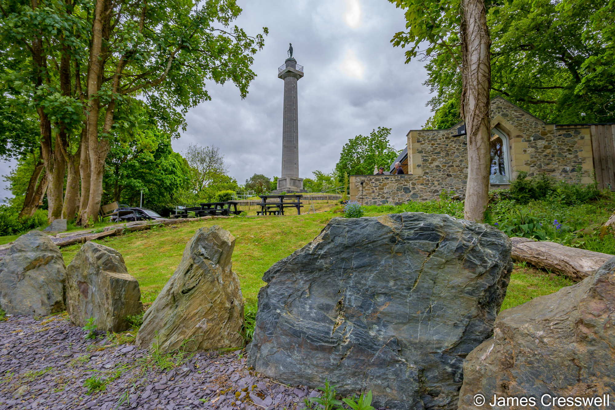
Top right: Blueschists exposed at the Marquess of Anglesey’s Column record high-pressure, low-temperature metamorphism formed within a subducting slab. These conditions are characteristic of subduction zones, where oceanic crust is carried to depth faster than it can heat up, producing minerals such as glaucophane that give the rock its distinctive blue colour. These rocks are Precambrian (Ediacaran) in age.
Bottom: The GeoWorld Travel group at the Great Orme Mines. Large-scale human activity on the Great Orme began around 4,000 years ago during the Bronze Age with the opening of several copper mines. The copper ore malachite contained within Carboniferous limestone was mined using stones and bone tools. It is estimated that up to 1,760 tonnes of copper was mined during the period. The mine was most productive in the period between 1700BC and 1400BC, after which most of the readily accessible copper had been extracted. The site was so productive that by 1600BC, there were no other copper mines left open in Britain because they could not compete with the Great Orme.
Day Ten: Snowdonia, Slate and Ice Age Landscapes
From Dinorwig Slate Quarry to Snowdon, Cwm Idwal and Darwin’s Boulders, this was a day of mountain geology, glaciation and big landscapes.
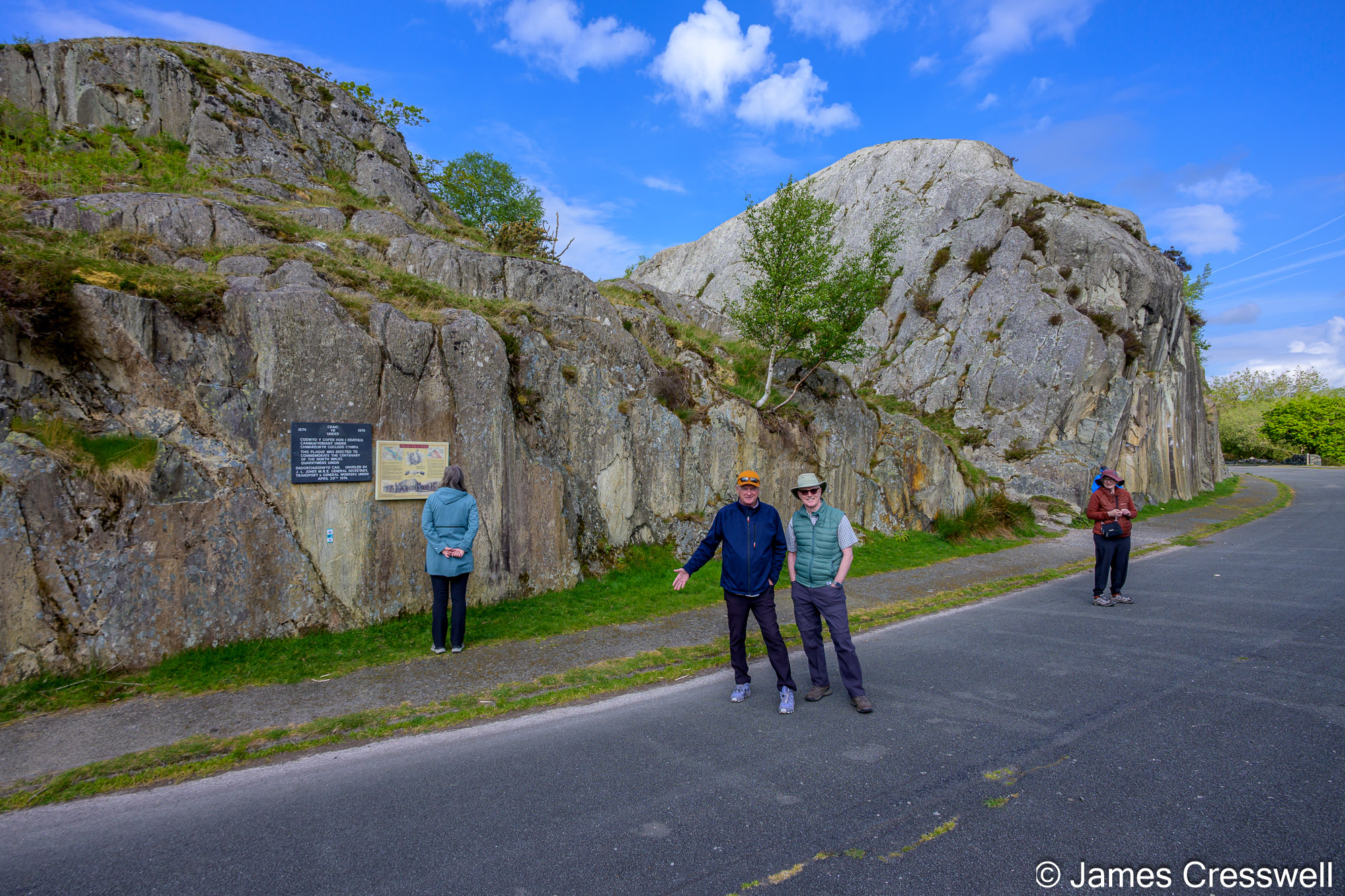
Top Left: Craig yr Undeb where we see the Padarn Tuff Formation, a thick sequence of felsic volcanic rocks erupted in the Late Neoproterozoic at around ~614–605 Ma. These are the oldest rocks seen on the trip and they were formed during major explosive eruptions, producing welded tuffs and ignimbrites deposited from hot pyroclastic flows. In the field they appear as pale, fine-grained rocks, commonly showing flattened textures caused by welding and later deformation.
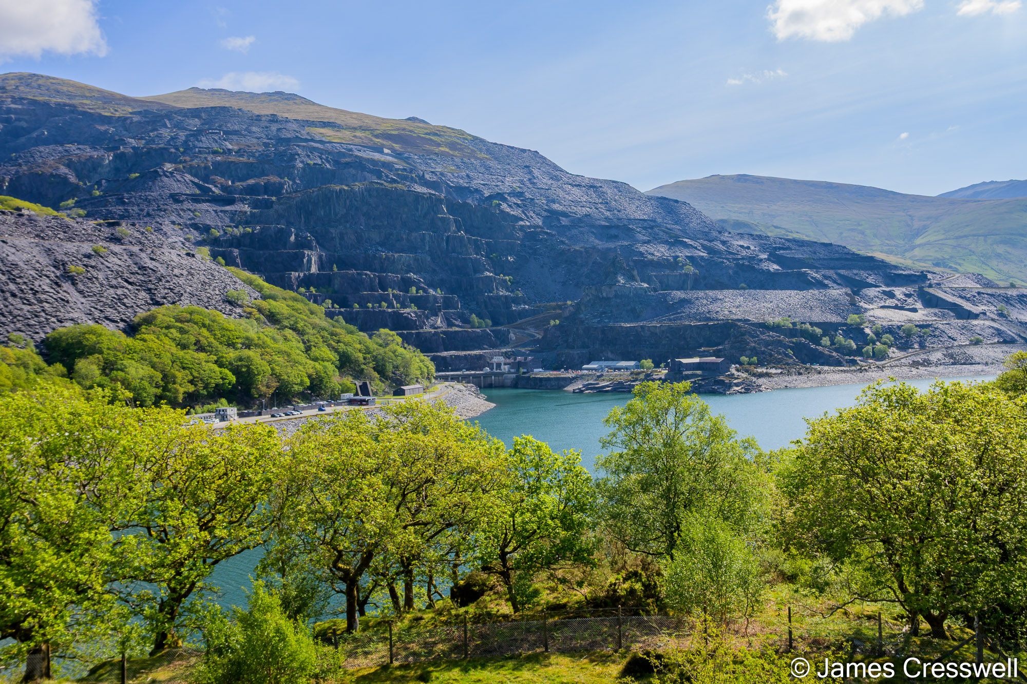
Top Middle: A view across to the vast workings of Dinorwig Slate Quarry. Once the second largest slate quarry in the world, it now forms part of The Slate Landscape of Northwest Wales World Heritage Site. The slate itself is Lower Cambrian in age and was originally deposited as mud in a marine basin around 500 million years ago. These rocks were studied extensively by Adam Sedgwick, and this region forms part of the Cambrian type area.
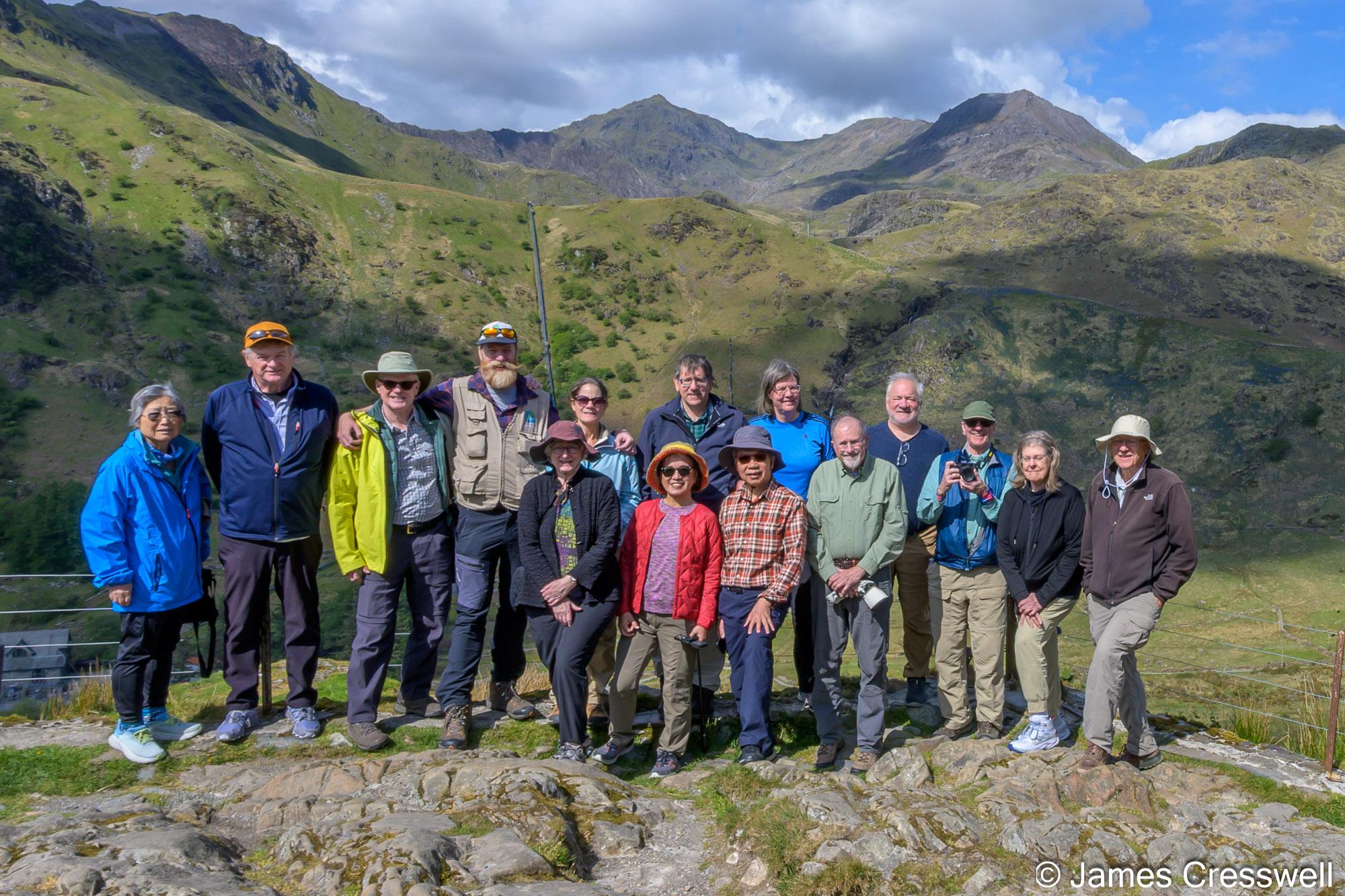
Top right: The GeoWorld Travel group at the Bethania Lookout Yr Wyddfa (Snowdon) viewpoint, in Eryri (Snowdonia) National Park. Yr Wyddfa (Snowdon) is, at 1,085m, both the highest mountain in Wales and the highest in the British Isles, south of the Scottish Highlands. The rocks that form Snowdon belong to the Snowdon Volcanic Group and were produced during intense Ordovician volcanism (Caradoc Series / ~460–450 Ma). This volcanism built a large volcanic complex, including caldera-forming eruptions that generated thick sequences of rhyolitic lava and volcanic ash (tuff), in places several hundred metres thick. The present summit lies close to the margin of this ancient volcanic centre, although the full extent of the caldera remains uncertain. These volcanic rocks were later deformed during the Caledonian Orogeny and now form part of a broad synclinal structure. During the last Ice Age, glaciation sculpted these hard volcanic rocks into the dramatic landscape seen today, carving corries and sharpening ridges such as Crib Goch and Y Lliwedd, and helping to create the distinctive pyramidal form of the mountain.
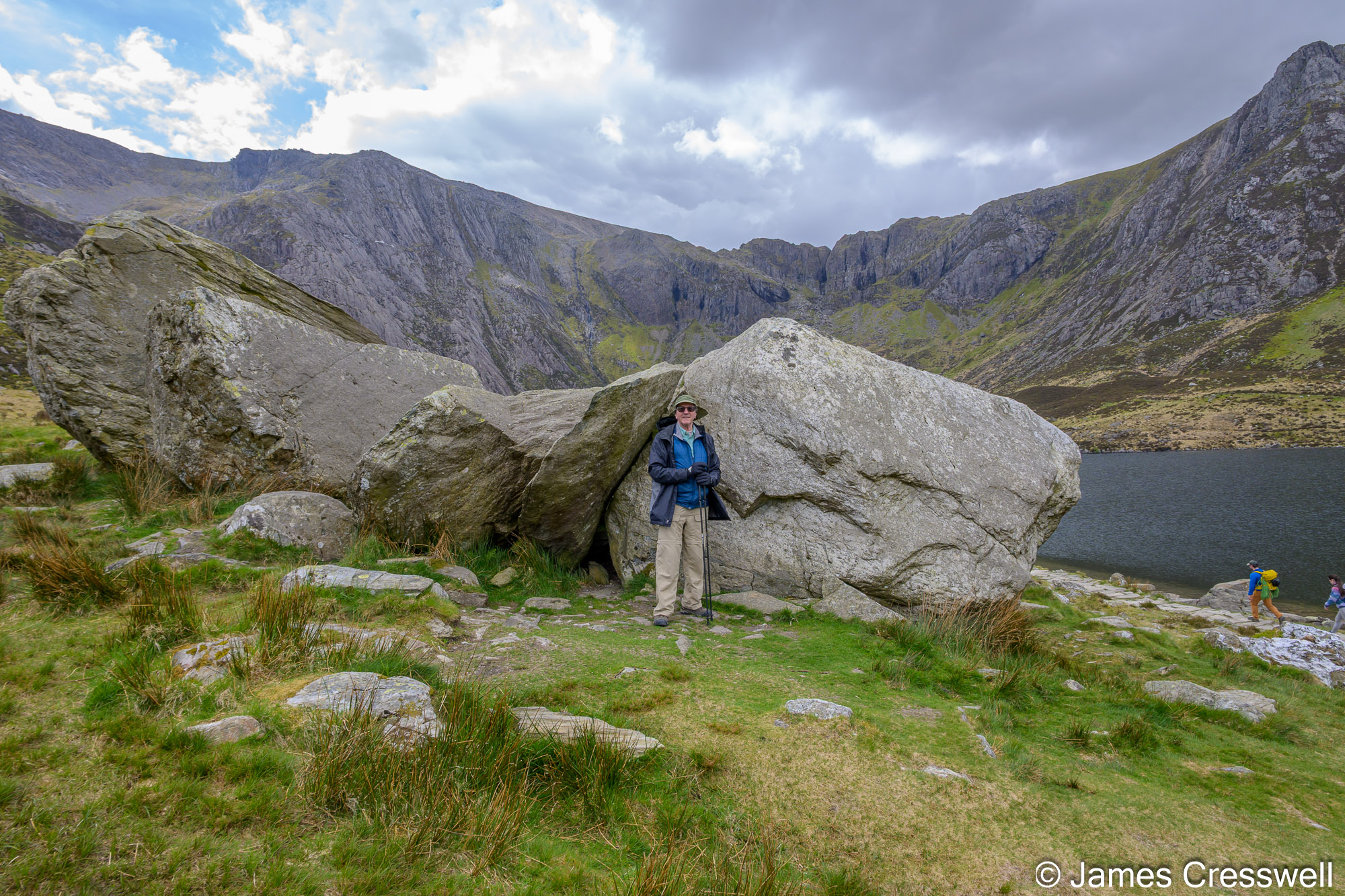
Bottom: David standing by Darwin’s Boulders in Eryri National Park. This locality is associated with Charles Darwin, who visited in 1831 with Adam Sedgwick as it was here that he observed large, scattered boulders around Llyn Idwal that contained marine fossils. He recognised that these rocks must have formed in an ancient ocean and were later uplifted, and that the boulders had been transported by ice—contributing to the early understanding that Britain had once experienced glaciation. The Idwal Syncline can be clearly seen in the background of this photo. The valley is cut along the hinge of this major fold, so that the surrounding beds dip towards the centre of the valley. The glacier that carved this cirque exploited this weakened hinge zone, linking deep geological structure directly to the present-day landscape.
Day Eleven: Shropshire and the Birthplace of Geological Thinking
We visited the Ercall Quarry, Ironbridge, Wenlock Edge and some of the most important sites in the type areas of the Silurian and Ordovician systems.
Left: The GeoWorld Travel group enjoying an introduction to the fossil forest at Stori Brymbo by Dr Tim Astrop.
Right: The location of the fossil forest at Stori Brymbo. During work on the Brymbo Steelworks site in 2003, several large, tree-like fossils were uncovered while opencast mining the overlying coal. After an initial assessment by Peter Appleton and Dr Jacqui Malpas, five years of excavation followed which revealed thousands of fossils and over 20 large tree-trunk-like structures with root networks perfectly preserved, some measuring up to 2.5m in height! Excavations are ongoing at this exceptional site.
Day Twelve: Ludlow, Mammoths and the Silurian Story
The final full day brought us to the Shropshire Hills, the Ludlow Bone Bed and key locations in the story of how the Ordovician and Silurian were understood.
Top Left: A view of Caer Caradoc seen from Lyth Hill, Shropshire. The geology of Caer Caradoc is very complex. At its base is a major fault (the Church Stretton Fault), but the mountain itself is made up of a mixture of Ediacaran, Cambrian and Ordovician aged rock. The name Caer Caradoc means “the fort of Caratacus (Caradog)”, a British king who led the Silures and Ordovices in a last stand against the Romans, traditionally believed to be here. It is from these tribes that the period names Silurian and Ordovician are derived.
Top Right: The Middle Quarry at the Ercall Quarries on The Wrekin. Here, is an exposure of one of the best unconformities in Britain. It is a classic nonconformity with Cambrian sedimentary layers resting directly on an eroded Ediacaran pink granophyre intrusion, representing a gap in geological time of around 10–20 million years. The basal sediments form a fossilised beach deposit: a conglomerate of reworked volcanic and granophyric material, overlain by quartz-rich sands with preserved ripple marks. This captures the moment when the Cambrian sea first advanced across the land, making this one of the clearest places in Britain to see the start of the Cambrian marine transgression. These rocks were later deformed during tectonic events, which is why the sedimentary layers are no longer horizontal.
Middle Right: Some of the ladies of the GeoWorld Travel group take a rest next to some shallow, marine Cambrian aged ripples in the Ercall Quarry.
Bottom: The Iron Bridge at Ironbridge in the Ironbridge Gorge World Heritage Site was built in 1779 and it was the world’s first major structure built entirely of cast iron. The bridge was designed by Thomas Farnolls Pritchard and built by Abraham Darby III at Coalbrookdale. It is made from around 1,700 individually cast parts, assembled using carpentry-style joints (mortise-and-tenon, dovetails). A single-span arch design puts the iron into compression, where it is strongest. Built on unstable, landslip-prone ground, the movement of the abutments has squeezed and distorted the arch. Its survival reflects an over-engineered design and the flexibility of its many joints.
Day Thirteen: Depart from London
The tour ended back near Heathrow, after an unforgettable journey through the landscapes, fossils and history of England and Wales.
Top Left: Classic bioherm (reef mound) structures are exposed beneath bedded strata at Knowle Quarry on Wenlock Edge. Wenlock Edge is one of Britain’s most important geosites and a globally significant Silurian reference locality, forming an ~18-mile-long limestone escarpment from Ironbridge to Craven Arms and giving its name to the Wenlock Epoch. The escarpment represents one of the best-developed Silurian reef systems in the world, formed around 425 million years ago in a shallow tropical sea south of the equator, on a marine shelf that graded westwards into deeper-water basinal shales.
Top Right: The Middle Quarry at the Ercall Quarries on The Wrekin. Here, is an exposure of one of the best unconformities in Britain. It is a classic nonconformity with Cambrian sedimentary layers resting directly on an eroded Ediacaran pink granophyre intrusion, representing a gap in geological time of around 10–20 million years. The basal sediments form a fossilised beach deposit: a conglomerate of reworked volcanic and granophyric material, overlain by quartz-rich sands with preserved ripple marks. This captures the moment when the Cambrian sea first advanced across the land, making this one of the clearest places in Britain to see the start of the Cambrian marine transgression. These rocks were later deformed during tectonic events, which is why the sedimentary layers are no longer horizontal.
Middle Right: The Condover Mammoth, on display at the Shropshire Hills Discovery Centre, which was discovered in 1986 near Shrewsbury. This exceptionally well-preserved woolly mammoth dates from the last Ice Age (Late Pleistocene, ~14,000–20,000 years ago) and is one of the most complete mammoth skeletons found in Britain. Preserved within glacial and river deposits, it provides evidence for the cold, steppe-like environments that existed here at the end of the Ice Age, offering a glimpse of the most recent chapter of Earth history.
Bottom: The GeoWorld Travel group at the Gorstian GSSP. A GSSP (Global Boundary Stratotype Section and Point), or “golden spike,” is a precisely defined point in a specific rock section that marks the official boundary between two intervals of geological time. It provides a globally agreed reference horizon that geologists use to correlate the same moment in Earth’s history worldwide. This site defines the base of the Gorstian Stage and marks the boundary between the older Wenlock Epoch and the younger Ludlow Epoch.
This tour is a celebration of just how much geological variety can be found close to home. From ammonites and trilobites to dinosaur tracks, coal mines, copper mines, slate quarries, mountain folds, glacial valleys and the birthplace of modern geology, England and Wales offer an extraordinary window into Earth history.
Our 60-photo review captures just some of the highlights from a packed and memorable 13 days. We hope you enjoy browsing through this photo diary of one of our most geologically rich tours.
For information on our other tours, visit our Destinations Page.

