
We can hardly believe it, but January 2025 saw the seventh running of our “Ocean Crust & Mountains of Mantle” trip to Oman! Once again we teamed up with the excellent Golden Highlands, who provided logistical support for the trip. This year, we welcomed 15 guests on our trip, coming from the UK, the USA, Portugal, South Africa and the UAE!
Route map of GeoWorld Travel’s Oman: Ocean Crust & Mountains of Mantle trip
Day One: Arrival in Muscat
Throughout the day our guests arrived in Muscat, gathering together for an evening meal and an opportunity to get to know each other and to discuss the adventure ahead.
Day Two: Muscat to Sohar
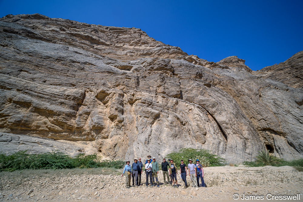
Top left: The Moho is the boundary between the earth’s crust and mantle. In most places it is a diffuse boundary but here, at Wadi al Abyad, it can be seen as a clear line. The base of the cliff is mantle rock (peridotite) and the upper part of the cliff is rock from the oceanic crust (gabbro).
Top right: A photograph of a drop stone (being pointed out) which fell from the base of floating ice and disturbed sediments beneath. This event happened in the Marinoan glaciation which was a Snowball Earth event that occurred around 640 million years ago.
Middle right: Rais stands on a very important geological contact of tropical dolomite capping 640-million-year-old “Snowball Earth” tillites. This shows an incredible story when the Earth went from ice-house conditions to green-house conditions in a virtual, geological instant.
Bottom right: An angular unconformity with tilted Ediacaran aged rocks beneath Permian rocks.
Bottom left: Marcus standing above the same angular unconformity shown in the previous photo. The Ediacaran aged rocks contain fossil stromatolites, and the Permian deposits are beach deposits.
Day Three: Sohar
Left: A fossilised black smoker that formed on the ocean floor, 90 million years ago, as part of the ophiolite complex. Black smokers exist at ocean spreading ridges where sea water passes through cracks in the ocean floor. When it gets near the mantle it’s super-heated and it can dissolve metal sulphides. As it returns to the surface and hits the cold water these metal sulphides precipitate out and form black ‘smoke’ (it looks like smoke but it’s precipitation in the sea water). The hill is red because the basalt, and all the iron in it, has been oxidised.
Top right: These are a special type of metal rich sediments called “umber sediments”. These sediments are formed by the precipitation from black smokers settling down on the mud of the ocean floor. They are very brittle and very hard; if you hit the sediment with a hammer, the hammer just bounces off!
Bottom right: Members of the GeoWorld Travel group walk on a very thick submarine lava flow. This lava flow was so thick that it began to form hexagonal cooling structures (visible in the foreground) when it slowly cooled.
Left: This is a sheeted dyke complex. All of the rock is made up of dykes – each intruding one another. The sheeted dyke complex occurs between the gabbro and pillow lavas in a typical ophiolite sequence. The dykes were formed as melt left the gabbro magma chamber to form erupting pillow lavas on the ocean floor.
Right: In the foreground is an outcrop of pillow lavas that are made up of the rare type of lava, boninite. Boninites are andesites rich in magnesium and titanium that nearly always form only over subduction zones, giving important information as to how Oman’s ophiolite formed. The GeoWorld Travel group are examining further outcrops of boninite in the background.
Left: Rashed sitting on the famous ‘Geotimes’ pillow basalts. These are arguably the world’s finest outcrop of pillow basalts. The basalts, part of the ophiolite sequence, erupted on the sea floor and were fed by dykes rising from the sheeted dyke complex below.
Right: A ziggurat, which is believed to be the only one of its kind in Arabia. A ziggurat is a stepped pyramid, and it would have been built by early copper miners who travelled to Oman from Mesopotamia.
Day Four: Sohar to Nizwa
Left: Members of the GeoWorld Travel group stand in front of a fossilised white smoker. A white smoker is like a black smoker but is formed by cooler temperatures (100°C rather than 300°C). Because these fluids are cooler, they precipitated fewer metal sulphides. Most of the deposits are opaline silicates.
Top right: Columnar cooling structures visible in a fallen block in front of a magnificent cliff made up of pillow basalts and numerous dykes cutting through the pillow basalts. At the top of the cliff there is a sill with columnar cooling structures. Additionally at this site archaeological remains can be found. People smelted copper and we could see the slag lying around.
Bottom right: The photograph is taken at the site of a former plate boundary, a subduction zone. The rocks in the foreground, on the right, are part of the “metamorphic sole” of the Semail Ophiolite. They were dragged down the subduction zone to great pressures and metamorphosed to amphibolite. The rocks in the mid-ground were once an underwater volcano crowned with a coral reef top. They are part of a unit of over-thrusted rocks called the Haybi nappe and have been trapped in the subduction zone hinge. The distant rocks are mantle rocks of the Semail Ophiolite. It is to the base of these that the metamorphic sole is welded.
Left: Marcus poses with spectacular folds in the Hawasina Nappe. These sediments originated as turbidites on the ocean floor and were thrust over the Arabian continental foreland in a nappe during the emplacement of the Semail Ophiolite. In the process the sedimentary layers became dramatically folded.
Right: Folds and faults in turbidite sediments of the Hawasina Nappe
Left: A dramatic scene where the rock on the left, Cretaceous-aged limestones of the Arabian foreland, is plunging beneath both rocks of the Hawasina Nappe and rocks of the Semail Ophiolite Nappe. The Arabian Foreland was dragged under the nappes by the pull of a subducting plate during the emplacement of the Semail Ophiolite. We are in effect viewing a fossilised subduction zone!
Right: The al-Ayn beehive tombs on a ridge in front of the Jebel Misht mountain, which is part of the Haybi nappe, and is a fossilised atoll trapped in the subduction zone. The 21 tombs of the Hafit type are Early Bronze Age and are a UNESCO World Heritage Site.
Day Five: Nizwa
Left: The Al Hoota Caves. These caves are the largest show caves in Arabia. They are in Cretaceous-aged limestones and have been formed by water enriched with dissolved carbon, which makes carbonic acid, that has passed through the rock dissolving it to form the caves. However, the caves are quite dry now and most of the cave formation would have happened in the last Ice Age when it was much wetter, and the water would have filled the cave to the roof.
Right: Looking down into the Grand Canyon of Arabia, giving a view of the entire sequence of Cretaceous and Jurassic rocks of the Arabian foreland. At the left of the photo is Jebel Shams which, at just over 3,000m, is Oman’s highest mountain.
Left: Coleman’s Rock (Hasat Bin Salt), on which the most important rock art in north-east Arabia is inscribed. It is a 6m high rock located on the wadi bed below the impressive landmark Jebel al Qal’ah.
Right: The GeoWorld Travel group at “Falaj Daris” UNESCO World Heritage Site. This is an irrigation system where people have dug boreholes or wells down to reach the water table, connecting between them to make a canal system, then allow the canal to flow out of the mountainsides and to the surrounding areas to irrigate them. These irrigation canals are thousands of years old.
Day Six: Nizwa to Wahiba Sands (Sharqiya Sands)
Top left: The group examine an outcrop of plagiogranite that formed at the boundary of the gabbro magma chamber and sheeted dyke complex due to either extreme fractional crystallisation or the partial melting of hydrated mafic crust.
Top right: Members of the GeoWorld Travel group examine an outcrop of limestone which resembles a skull, due to wind erosion. This limestone is part of the Haybi Nappe and was once part of an atoll. It contains many fossils.
Middle right: The ‘5 o’clock Moho’, so called because its best viewed in the late afternoon. The lower ¾ of the mountain is peridotite that formed in the earth’s mantle, while top quarter of the mountain is gabbro that formed in the earth’s lower crust. The boundary between is the Moho.
Bottom right: The GeoWorld Travel group waits for sunset in the Wahiba Sands.
Bottom left: The sun sets over the Wahiba Sands.
Left: Rashed and Peggy stargazing in the Wahiba Sands. Our campsite is visible on the right-hand side of the horizon.
Top right: Mary Lou milking a goat at our Wahiba Sands campsite.
Bottom right: Mary Lou feeds camels at our Wahiba Sands campsite.
Day Seven: Wahiba Sands (Sharqiya Sands) to Sur
Left: The oldest rocks in Oman: Precambrian gabbro dykes cut through Precambrian granites. These rocks formed during the accretion of terranes that later had a period of extension.
Top right: A close-up photo of rounded lapilli in an outcrop of kimberlite. Kimberlite is an ultramafic rock derived from very deep within the mantle. It often contains diamonds (although not in this case!) and is named after the famous diamond mine in Kimberley, South Africa.
Bottom right: James points to an outcrop of kimberlite on the beach.
Left: The GeoWorld Travel group at the ‘mother of all outcrops’. Red radiolarian chert is interbedded with white porcellanite. Porcellanite is an impure chert containing clay and carbonates. The outcrop is folded and faulted. The folds are mostly reclined chevron folds, hinge collapse is frequently observed. Some posting folding normal faults cut the folds. There are also minor thrust faults that were formed during the folding. The outcrop is folded because it is part of the Batain nappe which obducted with the Masirah Ophiolite, some 15-20 million years after the Semail Ophiolite.
Top right: A small pyrolusite opencast mine. The pyrolusite forms black layers between the layers of red radiolarian chert and white porcellanite. Pyrolusite is a manganese ore.
Bottom right: Stan examines the transition between porcellanite and red chert at the pyrolusite opencast mine.
Left: The GeoWorld Travel group examining an outcrop of carbonatite.
Top right: The GeoWorld Travel group examine an erosional notch cut into Eocene limestone in the Eemian interglacial. The holes were caused by marine molluscs that were boring holes into the rock, which demonstrates that this notch must have been created by the highest sea level at the time. The notch has been dated to around 120,000 years old which is the same age as the Eemian interglacial. This was a period in the last Ice Age, and at this site in Oman we can see that the sea level was 3.7m higher than the present day. What is concerning is that we already have a higher CO2 concentration today than in the Eemian.
Bottom right: Wave-cut platforms in Eocene and Quaternary aged rocks. The modern shore is at the base then, one step up, there is a wave-cut platform of Eocene limestone and another step up are the Quaternary coral fossils and, again another step up, is a recent conglomerate from rocks that were deposited in fluvial conditions. This stepped shoreline shows us the different sea levels of the past. The terraces presumably formed due to the uplift of the area after the emplacement of the Semail Ophiolite (which caused the land to rise) and there were lots of interesting fossils to be seen.
Day Eight: Sur to Muscat
Left: The start of the hike into Wadi Shab. Wadi Shab is a canyon cut through Eocene aged limestone and is regarded by many as Oman’s most beautiful wadi.
Top right: The slot which leads to the ‘secret cave’ at the end of Wadi Shab. To reach the cave one must swim across several pools and swim through this narrow opening.
Bottom right: The ‘secret cave’ at the end of Wadi Shab.
Left: Rais leans on one of the huge boulders that have been stacked up, or imbricated, by the huge force of a tsunami wave.
Right: The Bimmah Sinkhole. A sinkhole forms when a cave collapses into an open hole. This hole here actually has brackish water because the water comes from submarine caves which are connected to the open sea. However, the Bimmah Sinkhole is not actually a sinkhole, but a doline, which is a feature that occurs when there is a hole in soluble rock (like limestone) and the overlain insoluble rock layers sink into the hole in the soluble rock. In this case there is the Eocene limestone beneath, and on top of it is a thick conglomerate.
Day Nine: Muscat
Top left: Sue and Charles examine Carpholite bearing quartz‐rich veins within the Ruwi melange. The rock here was taken 30km down a subduction zone and shows shear bands that formed when it was forcing its way back to the surface after the subducting slab broke off.
Top right:The view of Wadi al Kabir in Muscat. The rocks in the foreground are Permian-aged limestones of the Arabian foreland. The rocks on the far side of the valley are peridotite mantle rocks. The former plate boundary lies in between.
Middle right: The Saith Hatat regional fold nappe syncline in Wadi al Mayh. This fold formed as the rock was being dragged down a subduction zone.
Bottom right: An ‘eye’ structure in the Wadi al Mayh mega sheath fold. This is the largest sheath fold in the world.
Bottom left: A large fold that is part of the Wadi al Mayh mega sheath fold.
Left: Members of the GeoWorld Travel group examine metasediments that have been metamorphosed to blueschist facies because they were dragged down a subduction zone.
Right: Paul points to the famous outcrop of eclogite on a beach near As Sifah. These rocks had once been basalt dykes and were part of the Arabian plate which had subducted the furthest underneath the ophiolite.
Left: A sample of eclogite which contains a green mineral called omphacite (a type of pyroxene), and some well-formed brown-red coloured garnet crystals.
Right: A view down on to Riyam Park, Muscat. The banded rock is peridotite, rock that was originally part of the mantle. The darker bands are harzburgite which contains olivine and pyroxene, while the lighter bands are dunite, which is nearly 100 % olivine. The holes form where dunite has been weathered away forming the mineral magnesite. The white structure on top of the hill in the distance is the Riyam Censer – a giant, monumental frankincense burner!
Day Ten: Departure from Muscat
With the main tour complete, some of our guests headed home, whilst others joined Golden Highlands for an extra city tour of Muscat. One couple even took the opportunity to visit the Empty Quarter – a truly wonderful experience.
Thank you to our 2025 group for joining us in Oman – it was a pleasure to travel with you and to share the wonderful geology of this fascinating country with you. And thank you again to Golden Highlands for supporting us and facilitating another excellent tour.
We will be returning to Oman again next year, so please check out our website (https://www.geoworldtravel.com/oman.php) for further details and future trip dates.
