
Journey into one of the world’s greatest mountain ranges
Just over a week ago, we returned from an unforgettable ten-day journey through Switzerland, exploring some of Europe’s most spectacular mountain scenery and discovering the remarkable geological story behind it.
Travelling from Geneva through the Jura Mountains, across the high Alps and back via the Rhône Valley, our group experienced world-famous landscapes, classic geological sites and breathtaking mountain views. Along the way we traced the collision between Africa and Europe, walked across rocks that once lay beneath an ancient ocean, stood beside rapidly retreating glaciers and visited locations that transformed our understanding of how mountains are built.
The scenery alone is enough to make Switzerland one of the world’s great travel destinations. But when you understand the geology beneath your feet, every mountain, valley and cliff tells an extraordinary story spanning hundreds of millions of years.
Here’s a look back at our adventure.
Route map of GeoWorld Travel’s ‘An Alpine Adventure’ tour

Day One: Welcome to Geneva
Our group gathered in Geneva, where everyone had the opportunity to meet before the adventure began. Over dinner we discussed the exciting journey ahead, introducing the geology that would accompany us throughout the tour and getting to know one another before setting off into the Alps.
Day Two: The Jura Mountains and the birthplace of the Jurassic
Our first full day took us along the shores of beautiful Lake Geneva before continuing north towards Lake Neuchâtel and the Jura Mountains.
Our first major stop was the spectacular Creux-du-Van, an enormous natural limestone amphitheatre carved by glacial erosion. Standing at the edge of its towering cliffs, we examined the folded rocks that give the Jura Mountains their distinctive appearance while enjoying panoramic views stretching towards the distant Alps.
Nearby we visited the famous Pierre à Bot, one of Switzerland’s best-known glacial erratics. This giant boulder travelled all the way from the Mont Blanc massif during the last Ice Age and became central to Louis Agassiz’s revolutionary work demonstrating that glaciers once covered much of Europe.
Later we explored the historic town of Valangin, the type locality for the Valanginian Stage of the Early Cretaceous, before spending time in Neuchâtel’s excellent Natural History Museum, learning more about the region’s geological heritage.
We ended the day in the charming lakeside town of Neuchâtel.
Left: Creux du Van lies in the Jura Mountains, the type area of the Jurassic Period. This spectacular natural amphitheatre formed in three main stages: 1. Jura mountain building folded the rocks into the Soliat anticline, creating fractures in the limestone. 2. Karst dissolution exploited these fractures, enlarging them to form an erosional valley known as a combe. 3. Quaternary glaciers and frost weathering dramatically enlarged the head of the combe into the magnificent limestone cirque seen today. Often referred to as the “Grand Canyon of Switzerland”, Creux du Van is around 1,400 metres wide, with cliffs rising to about 160 metres above the forest floor.
Top right: View from the summit of Chaumont across Lake Neuchâtel towards the Alps. The prominent snow-covered peak is Mont Blanc, the highest mountain in Western Europe, standing 4,805.6 metres above sea level.
Bottom right: Typical thrust faulting and folding in the Jurassic limestones of the Jura Mountains, exposed in La Cernia Quarry near Neuchâtel. The inclined limestone beds have been compressed and stacked by faulting during the formation of the Jura Mountains.
Day Three: The Top of Europe
After travelling through the Bernese Alps we arrived in Grindelwald beneath the immense north faces of the Eiger, Mönch and Jungfrau.
From there we boarded the famous mountain railway to Jungfraujoch, Europe’s highest railway station at 3,463 metres above sea level.
Few places illustrate the power of glaciation quite like this. Surrounded by snow-covered peaks, we looked across the immense Aletsch Glacier – the largest glacier in the Alps – and examined classic glacial landforms shaped over thousands of years.
The combination of world-class geology and breathtaking scenery made this one of the highlights of the entire tour.
Left: The GeoWorld Travel group at Pierre à Bot, a famous glacial erratic of Mont Blanc granite. The boulder was transported over 100 km by the Rhône Glacier during the last Ice Age and was later used by Louis Agassiz as key evidence for his revolutionary theory of glaciation.
Right: A cast of the Triassic dinosaur Plateosaurus, based on a skeleton discovered in the Gruhalde clay pit at Frick, northwestern Switzerland, on display in the Natural History Museum of Neuchâtel. Plateosaurus lived around 210 million years ago and is one of Europe’s best-known early dinosaurs.
Left: Some of the GeoWorld Travel group examine the cobbles beneath their feet in Neuchâtel’s old town. These rounded stones once formed the bed of the River Seyon, which flowed through the centre of the city until it was diverted into a tunnel in 1843. The cobbles include a wide variety of Alpine rock types, such as serpentinite, transported to Neuchâtel by glaciers during the Ice Ages before being reworked by the river.
Right: The GeoWorld Travel group on the Eiger Express from Grindelwald to Eigergletscher, passing alongside the iconic 1,800m-high north face of the Eiger, one of the world’s most famous and challenging climbing faces.
Left: The GeoWorld Travel group on the Eiger Express from Grindelwald to Eigergletscher, passing alongside the iconic 1,800m-high north face of the Eiger, one of the world’s most famous and challenging climbing faces.
Right: A spectacular recumbent fold within the Helvetic nappes, photographed from Eigergletscher station. The fold appears to be associated with a thrust fault beneath it.
Day Four: Understanding how mountains are built
Today’s journey took us through the beautiful Lake Lucerne region before entering the UNESCO World Heritage Site known as the Tectonic Arena Sardona.
Here we visited one of Switzerland’s most famous geological locations – the Glarus Thrust.
At Lochsite we examined one of geology’s greatest puzzles, where ancient rocks over 250 million years old lie directly above rocks less than 50 million years old. This remarkable relationship helped scientists understand that enormous slabs of rock can be pushed many kilometres over younger rocks during mountain building.
Later we travelled by cable car to Tschinglen Alp before taking a gentle walk to Firstboden, where magnificent views of the Glarus Thrust and the famous Martin’s Hole perfectly illustrated the immense forces that created the Alps.
Left: The scene outside the Jungfraujoch complex, photographed from the uppermost reaches of the Great Aletsch Glacier. The summit of the Jungfrau (4,158 m) rises in the background, while the rocky saddle of the Jungfraujoch is crowned by the Sphinx Observatory. In summer, visitors can enjoy snow sports on the glacier.
Top Right: One of the major Alpine shear zones exposed near the Jungfraujoch. Here, intense deformation during Alpine mountain building juxtaposed different units of the Aar Massif crystalline basement, producing a complex network of ductile shear zones and faults.
Bottom Right: Sophie descends into the Ice Palace at the Jungfraujoch. Carved within the upper Aletsch Glacier, the Ice Palace consists of tunnels and chambers first excavated in the 1930s, allowing visitors to walk through the interior of Europe’s largest glacier.
Left: The Great Aletsch Glacier, viewed from the Jungfraujoch. At around 20km long, it is the largest glacier in the Alps. The striking dark medial moraines mark where tributary glaciers have merged, with the lateral moraines of the individual ice streams joining to form long ribbons of debris down the centre of the glacier. On the right-hand side of the image is the summit of Eggishorn (2,869m), which offers one of the finest panoramic views of the Aletsch Glacier and was visited later in the trip.
Right: Mount Pilatus, viewed across Lake Lucerne. The mountain is composed mainly of Cretaceous limestones belonging to the Helvetic nappes, which have been thrust northwards over younger Molasse Basin sediments during Alpine mountain building. In the foreground, the waters of Lake Lucerne occupy a valley shaped by Quaternary glaciers.
Left: The Grosser Mythen (1,898m) and Kleiner Mythen (1,811m), viewed from Schwyz. These striking peaks are erosional remnants of the Klippen Nappe, a slab of Late Jurassic limestone thrust northwards during Alpine mountain building. Differential erosion of the hard limestones and softer underlying rocks has created the distinctive notch in Kleiner Mythen and the saddle separating the two peaks. They are among the best-known ‘klippen’ of the Alps-isolated erosional remnants of a thrust sheet, from which the Klippen Nappe takes its name.
Right: View from the Bohl viewpoint across Lake Lauerz towards the Rigi massif. Rigi is composed of Subalpine Molasse-sediments eroded from the rising Alps and deposited in the Molasse Basin before being folded and uplifted. At the western end of the massif (left-hand side of the image), the Wildhorn Nappe has been thrust over the Molasse, marking the Alpine thrust front and the transition into the Helvetic nappes
Day Five: Glaciers past and present
Our morning began beside the Rhone Glacier, source of one of Europe’s great rivers.
Perhaps nowhere else in Switzerland is the impact of climate change more immediately visible. Over the past 120 years the glacier has retreated around 1.3 kilometres, leaving behind striking evidence of its former extent.
Later we returned to the Jungfrau-Aletsch UNESCO World Heritage Site via cable car, reaching Eggishorn for arguably the finest viewpoint overlooking the mighty Aletsch Glacier.
Standing high above this vast river of ice offered an unforgettable perspective on the largest glacier in the Alps and the powerful forces that continue to shape the landscape today.
That evening we travelled to Täsch, our base for exploring the Matterhorn.
Left: The GeoWorld Travel group examining the Glarus Thrust at Lochsite, one of the world’s most famous geological outcrops. Here, 300–200-million-year-old Verrucano rocks have been thrust more than 100km over much younger 35–30-million-year-old Eocene flysch. The Glarus Thrust became one of the key pieces of evidence that mountains are built by large-scale overthrusting, and today forms the heart of the UNESCO Swiss Tectonic Arena Sardona World Heritage Site
Top right: Viewed from the Elm–Tschinglenalp cable car station, the Tschingelhörner expose three contrasting rock units: Permian Verrucano at the top, Jurassic limestone beneath, and Eocene flysch below. The Verrucano has been thrust more than 100km over the younger Jurassic limestone and flysch along the Glarus Thrust. Martin’s Hole is eroded through the Jurassic limestone where a tectonic sliver of flysch has been emplaced. The hole formed where the shear zone marking the contact between the flysch sliver and the surrounding Jurassic limestone is intersected by a small brittle fault, creating a zone of weakness exploited by erosion. Twice each spring and autumn, the rising sun shines through Martin’s Hole and briefly illuminates the church at Elm.
Left: A spectacular recumbent fold in the Jurassic limestones of the Axen Nappe, seen from Klausen Pass. The pass is one of the classic localities for viewing large-scale folds within the Helvetic nappes, exposed by glacial erosion. These folds formed during Alpine compression as the nappes were transported northwards over the European continental margin.
Right: The Rhône Glacier is the largest glacier in the Uri Alps and the source of the River Rhône, which flows through Switzerland and France before reaching the Mediterranean Sea. The glacier rests on Carboniferous granite belonging to the Aar Massif, the autochthonous crystalline basement of the European continent. Since the late 19th century, the glacier has retreated by more than 1.3km and has thinned dramatically. The photograph shows the newly formed proglacial lake and polished granite bedrock exposed by the retreating ice. The lake did not even exist in 2018, illustrating just how rapidly the glacier has changed in recent years. The next photo shows the same view, but 4 years ago in 2022 – the glacial retreat is, sadly, very clear to see.
Day Six: The Matterhorn and the remains of an ancient ocean
One of the most anticipated days of the tour took us into the iconic mountain village of Zermatt, dominated by the unmistakable pyramid of the Matterhorn.
The geology here is every bit as remarkable as the scenery.
Travelling by cable car to Klein Matterhorn, we explored rocks that once formed part of the floor of the ancient Tethys Ocean before Africa and Europe collided. Walking through tunnels cut into these rocks, and even through glacial ice itself, provided an extraordinary opportunity to witness both tectonic and glacial processes up close.
Later we followed sections of the Matterhorn Glacier Trail, where recently exposed rocks reveal fragments of ancient oceanic crust transformed deep within the Earth before eventually being uplifted to almost 4,000 metres above sea level.
With the Matterhorn towering above us throughout the walk, it was a truly unforgettable day.
Left: View of the Rhône Glacier from exactly the same viewpoint as the previous photo. This was taken 4 years ago in 2022 and the glacial retreat is, sadly, very clear to see.
Right: The white geotextile blankets mark a small remnant of ice preserved from melting. This protected ice is all that remains of the former Rhône Glacier Ice Grotto (Ice Palace), while the surrounding glacier has wasted away. When we last visited in 2024, the glacier surface extended to the line of these blankets. By 2026, almost all of the surrounding ice had disappeared, dramatically illustrating the glacier’s rapid retreat.
Left: Eggishorn (2,869m) provides one of the finest panoramic views of the 23km-long Great Aletsch Glacier, the largest glacier in the Alps. From this viewpoint, three major ice streams—the Grosser Aletschfirn, Jungfraufirn and Ewigschneefäld—merge to form a single trunk glacier. Their former lateral moraines become the striking medial moraines that trace the paths of the converging ice streams downstream. The Great Aletsch Glacier is the centrepiece of the UNESCO Swiss Alps Jungfrau–Aletsch World Heritage Site.
Right: Outside the Zermatt Museum stands a spectacular block of metamorphosed pillow basalt (eclogite). The original pillow structures, formed by basaltic lava erupting onto the floor of the Tethys Ocean, are still clearly visible despite the rock having undergone high-grade metamorphism. During the Alpine collision, these oceanic basalts were buried to depths of around 50–70km, where high pressures transformed them into eclogite. They were subsequently exhumed during mountain building and later exposed by erosion, preserving the remarkable pillow structures. The boulder was collected from the mountains above Zermatt and placed outside the museum as an excellent example of the oceanic crust preserved within the Penninic nappes.
Left: The Matterhorn (4,478m), viewed from Zermatt. Widely regarded as the world’s most famous mountain, its distinctive pyramidal shape has been carved by glaciers eroding four steep faces and intersecting arêtes. Geologically, the summit consists of African continental crust (Dent Blanche Nappe) thrust over rocks of the former Tethys Ocean and the European continental margin during the Alpine collision.
Right: The GeoWorld Travel group ascends towards the Klein Matterhorn (3,883m) aboard the cable car. Beneath us lies the Upper Theodul Glacier (Oberer Theodulgletscher), which flows from the Breithorn Plateau. Rapid glacier retreat has exposed large areas of bedrock belonging to the Theodul Unit, recently recognised as a sliver of continental crust preserved within the oceanic rocks of the Zermatt–Saas ophiolite nappe.
Day Seven: Along the Europe–Africa collision zone
Today’s excursion into the beautiful Hérens Valley continued the story of the Alpine collision.
Here we explored rocks that originated both within the ancient ocean and on the African continent itself, allowing us to piece together the extraordinary events that closed the Tethys Ocean and built the Alps.
Combined with spectacular glacial valleys and dramatic mountain scenery, the geology made for another fascinating day before spending the evening in the historic town of Sion.
Left: The observation deck at the summit of the Klein Matterhorn (3,883m), the highest point in Europe that can be reached entirely by cable car. Less than 1 km from the Italian border, it offers one of the finest geological panoramas in the Alps. Dominating the view is the Matterhorn, whose summit is composed of African continental crust (the Dent Blanche Nappe) thrust over the Zermatt–Saas Ophiolite, a remnant of the Piedmont Ocean. In effect, you are looking at a former plate boundary.
Top right: A natural crevasse exposed within the ice cave at Matterhorn Glacier Paradise. The cave has been excavated into the glacier, allowing visitors to see the internal structure of the ice. The crevasse formed as the glacier flowed downslope and fractured under tension, providing a glimpse into the hidden network of cracks that develop within moving glacier ice.
Bottom right: Descending by cable car above the Lower Theodul Glacier. The glacier has become fragmented by rapid retreat, exposing extensive areas of bedrock belonging to the Theodul Unit, recently recognised as a sliver of continental crust preserved within the Zermatt–Saas Ophiolite. On the right, the Gorner Glacier occupies the main valley. The broad grey trimlines on the valley sides mark the glacier’s former surface, showing that the ice has thinned by well over 100m in recent decades.
Left: Garnet–phengite schist of the Theodul Glacier Unit, seen beside the Matterhorn Glacier Trail. The rock originally formed as continental crust before being caught up in the Alpine collision and metamorphosed under high-pressure conditions. The conspicuous red garnet crystals and silvery phengite mica record burial to depths of tens of kilometres before the rock was returned to the surface. The Theodul Glacier Unit is now recognised as a sliver of continental crust enclosed within the Zermatt–Saas ophiolite nappe.
Right: View along the Matterhorn Glacier Trail. In the foreground, the blue-green rocks are serpentinite of the Zermatt–Saas ophiolite, representing mantle rocks from the floor of the former Piedmont Ocean. They are separated by a thrust fault from the reddish garnet–phengite schists of the Theodul Glacier Unit, a sliver of continental crust enclosed within the ophiolite nappe. Immediately behind the schists, although largely hidden from view, are eclogites formed by high-pressure metamorphism of ocean-floor basalts. The distant peaks belong to the Dent Blanche nappe and are composed of African continental crust that was thrust over the Zermatt–Saas ophiolite during the Alpine collision.
Left: Boulder of eclogite derived from oceanic basalt of the Zermatt–Saas ophiolite, found a short distance off the Matterhorn Glacier Trail. During the Alpine collision, this former ocean-floor basalt was buried to depths of tens of kilometres and transformed into eclogite. Elsewhere along the trail, eclogites derived from basaltic dykes within the continental Theodul Glacier Unit can also be seen, showing that both the oceanic crust and the adjacent continental sliver shared the same high-pressure metamorphic history.
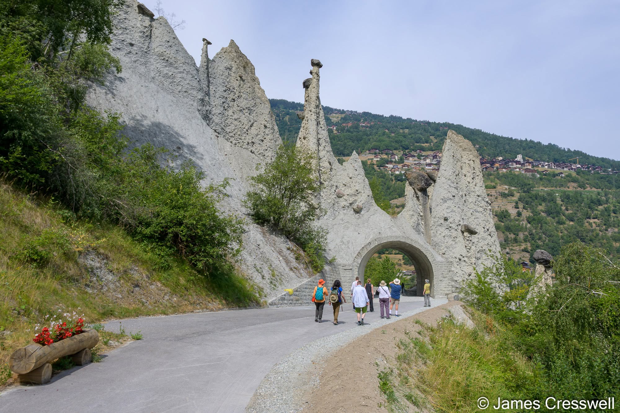
Top right: The Pyramides d’Euseigne in the Val d’Hérens. These spectacular earth pyramids are erosional remnants of Late Pleistocene glacial moraine. Large boulders perched on their summits act as protective capstones, shielding the underlying unconsolidated sediment from erosion while the surrounding moraine is washed away. The pyramids, typically 10–15m high, continue to evolve as erosion gradually reshapes the landscape.
Bottom right: Members of the GeoWorld Travel group enjoying a guided tour of the Centre de Géologie et Glaciologie in Evolène. The museum provides an excellent introduction to the geology and glacial history of the Val d’Hérens, with displays explaining Alpine tectonics, glaciers, and the evolution of the surrounding landscape.
Day Eight: Ancient landscapes beneath modern Switzerland
Our exploration continued around Sion with visits to several fascinating geological locations.
At Sanetsch we examined a major unconformity recording the beginning of Alpine mountain building, alongside huge folded rock sequences that beautifully demonstrate the immense forces involved.
Later we enjoyed a boat trip across the remarkable Saint-Léonard Underground Lake, Europe’s largest natural subterranean lake, formed through the dissolution of ancient gypsum deposits deep beneath the surface.
The day concluded with visits to the impressive medieval castles overlooking Sion.
Top left: Members of the GeoWorld Travel group at Ferpècle, one of the finest locations in the Alps for studying glacier retreat. This photograph was taken where the Mont Miné and Ferpècle glaciers still converged as a single glacier in the 1980s. Continued retreat has left a broad ice-free valley between the two glacier tongues. The walk crosses a succession of moraines marking the retreat of the Mont Miné Glacier since its Little Ice Age maximum in 1864. The surrounding mountains are composed of orthogneisses of the Austroalpine Dent Blanche nappe, representing continental crust derived from the former African margin.
Top right: Members of the GeoWorld Travel group walking across the spectacular karst landscape of the Sanetsch Pass. This walk crosses the Diablerets Nappe of the Helvetic nappe complex, close to its tectonic boundary with the overlying Mont-Gond Nappe, which forms the browner-coloured mountains beyond. The pale limestone pavement is Urgonian Limestone (Barremian–Aptian, c.125–113 Ma), deposited on a warm, shallow tropical carbonate platform similar to the modern Bahamas. Following uplift and erosion, these limestones were deeply karstified before being overlain, after a gap of approximately 50 million years, by Eocene marine sediments and Oligocene flysch deposited in a deep foreland basin during Alpine mountain building.
Top left: Entrance to the Saint-Léonard subterranean lake, the largest natural underground lake in Europe. The cave has formed by the dissolution of Triassic gypsum, part of an evaporite sequence deposited as the supercontinent Pangaea began to break apart. Repeated flooding and evaporation of restricted seawater produced thick layers of gypsum and salt before the opening of the Tethys Ocean. These evaporites, together with associated marble and coal shale, formed part of the sedimentary cover of the Briançonnais microcontinent, now incorporated into the Penninic nappe complex. The cave lies close to the tectonic boundary between the Penninic and Helvetic nappe complexes.
Top right: Visitors explore the Saint-Léonard subterranean lake by flat-bottomed boat. The lake occupies a cavern dissolved within Triassic gypsum, part of an evaporite sequence deposited during the initial breakup of the supercontinent Pangaea. At approximately 300m long, it is the largest natural underground lake in Europe open to the public.
Middle right: The Emosson Dam, completed in 1973, is the third-highest dam in Switzerland at 180 m high. It forms part of one of Switzerland’s largest hydroelectric schemes, supplying electricity through an extensive gravity-fed network that collects meltwater from surrounding rivers and glaciers. The original Emosson Dam, completed in 1925, now lies submerged beneath the reservoir. During planning in the 1960s, the Swiss–French border was adjusted so that the entire dam would lie within Switzerland.
Bottom: Mont Blanc (4,805.59m / 15,766ft), photographed from the Emosson Dam. The highest mountain in the Alps and western Europe, it straddles the French–Italian border. The massif consists predominantly of Carboniferous granite, emplaced during the Variscan mountain-building event around 300 million years ago. During the later Alpine orogeny, this ancient European continental basement was uplifted to form the Mont Blanc Massif.
Day Nine: Mont Blanc and the Lavaux Vineyards
Our final full day combined spectacular scenery with one last geological story.
Travelling by funiculars and panoramic railway, we climbed towards the Emosson Dam, enjoying magnificent views across the Mont Blanc massif from one of Switzerland’s most scenic mountain routes.
We then visited the dramatic Trient Gorge, where rushing water has carved deep into the bedrock, before continuing to the UNESCO-listed Lavaux Vineyard Terraces overlooking Lake Geneva.
Here we explored how ancient river deposits, later sculpted by the Rhône Glacier, created the stepped slopes that now support one of Switzerland’s most famous wine-growing regions.
Returning to Geneva, we celebrated an incredible journey through one of the world’s most geologically fascinating countries.
Top left: Viewed from the crest of the Emosson Dam, the smaller dam in the distance is the Vieux Emosson Dam. Both dams are built on the Carboniferous granitic basement of the Aiguilles Rouges Massif. Beyond the reservoir rise Middle Triassic sedimentary rocks of the Vieux Emosson Formation, deposited across coastal tidal flats unconformably above the granite. These rocks preserve one of Europe’s most important vertebrate footprint localities. Although long thought to be dinosaur tracks, the footprints are now known to have been made around 240 million years ago by large crocodile-like archosaurs (pseudosuchians), before the evolution of the first true dinosaurs. Unlike the nearby Helvetic nappes, these rocks remain attached to their original European basement and were not transported long distances during Alpine mountain building.
Top Right: Members of the GeoWorld Travel group touring the interior of the Emosson Dam. Here our guide, Katrin, explains one of the dam’s pendulums, which is suspended inside the concrete structure to monitor tiny movements caused by changes in water level, temperature and the immense weight of the dam itself. Instruments such as these have been used for decades to ensure the long-term stability and safety of large concrete dams.
Middle Right: Our GeoWorld Travel group poses with the dinosaur sculpture outside the Emosson visitor centre. The sculpture commemorates the internationally important Middle Triassic archosaur tracksites preserved high above the reservoir. Although the footprints were originally thought to have been made by dinosaurs, they are now known to have been left by large crocodile-line archosaurs around 240 million years ago. The cyclist’s helmet celebrates the 2016 Tour de France stage finish at Emosson, which was made possible by a temporary construction tunnel through the dam that allowed the race caravan and support vehicles to leave the otherwise dead-end valley.
Bottom Right: Our GeoWorld Travel group gathers around a relief model of the Emosson hydroelectric scheme during our guided tour of the dam. The model shows the extensive gravity-fed network of tunnels, reservoirs and water intakes that collect meltwater from rivers and glaciers across the Mont Blanc Massif in both Switzerland and France before it is channelled to generate hydroelectric power. It is one of the largest hydroelectric systems in the Alps and an excellent way of appreciating the scale and complexity of the engineering.
Top left: Sophie braves the Emosson zipline, with the snowfields and glaciers of Mont Blanc (4,805.6m), the highest mountain in the Alps and western Europe, providing a spectacular backdrop. The mountain is carved into 300-million-year-old Carboniferous granite, uplifted during Alpine mountain building from Europe’s ancient continental crust.
Top Right: Le Dent de Morcles (2,969m) contains one of the world’s finest exposures of a giant recumbent (isoclinal) fold. The Cretaceous limestones and younger Palaeogene flysch were originally deposited as horizontal layers along the European continental margin before being detached from their crystalline basement, transported many kilometres during the Alpine collision, and folded into this spectacular structure. The fold forms the leading edge of the Morcles Nappe, one of the major Helvetic nappes.
Middle Right: Château de Chillon occupies a small limestone island on the shore of Lake Geneva, left isolated as the Rhône Glacier retreated at the end of the last Ice Age. This naturally defensible position controlled the narrow route between the lake and the mountains, allowing the Counts of Savoy to monitor traffic and collect tolls from travellers passing between northern Europe and Italy. The present castle was developed between the 12th and 16th centuries and remains one of Switzerland’s best-preserved medieval fortresses.
Bottom Right: The spectacular Lavaux vineyard terraces, overlooking Lake Geneva, have been cultivated since the 11th century and were designated a UNESCO World Heritage Site in 2007 in recognition of the remarkable interaction between people and the landscape over nearly a thousand years. The vineyards are planted on 20-million-year-old Molasse conglomerates, deposited in the foreland basin that developed as the Alps rose. During the last Ice Age, the Rhône Glacier differentially eroded alternating hard conglomerate and softer sandstone beds, creating the characteristic stepped slopes that provide ideal conditions for terraced viticulture.
Top left: Creux du Van lies in the Jura Mountains, the type area of the Jurassic Period. This spectacular natural amphitheatre formed in three main stages: 1. Jura mountain building folded the rocks into the Soliat anticline, creating fractures in the limestone. 2. Karst dissolution exploited these fractures, enlarging them to form an erosional valley known as a combe. 3. Quaternary glaciers and frost weathering dramatically enlarged the head of the combe into the magnificent limestone cirque seen today. Often referred to as the “Grand Canyon of Switzerland”, Creux du Van is around 1,400 metres wide, with cliffs rising to about 160 metres above the forest floor.
Top Right: View from the summit of Chaumont across Lake Neuchâtel towards the Alps. The prominent snow-covered peak is Mont Blanc, the highest mountain in Western Europe, standing 4,805.6 metres above sea level.
Bottom Right : Typical thrust faulting and folding in the Jurassic limestones of the Jura Mountains, exposed in La Cernia Quarry near Neuchâtel. The inclined limestone beds have been compressed and stacked by faulting during the formation of the Jura Mountains.
Thank you to another fantastic group
A huge thank you to everyone who joined us for this wonderful adventure. It was a pleasure to share Switzerland’s incredible landscapes and geological history with such an enthusiastic group.
From world-famous glaciers and towering Alpine peaks to ancient ocean floors and classic geological discoveries, every day revealed another chapter in the extraordinary story of how the Alps came to be.
We’ll be returning to Switzerland in 2028, and we’d love you to join us. If this journey has inspired you, get in touch to register your interest and experience one of Europe’s most spectacular geological destinations for yourself.
For information on our other tours, visit our Destinations Page.