Scotland is one of the most important places in the world for anyone interested in geology. Its landscapes are spectacular in their own right, but they also tell some of the great stories in Earth science, from the discovery of deep time to ancient rocks, former volcanoes, dinosaur footprints, glaciated valleys and world-famous geological structures.
That is why our Scotland tour is aptly named The Birth of Geology.
Just over two weeks ago, we completed another wonderful 9-day journey from Edinburgh through the Highlands, the North West Highlands Geopark, the Isle of Skye, Lochaber and back to Edinburgh. Along the way, our group visited a remarkable collection of geological sites, including 2 World Heritage Sites, a UNESCO Global Geopark, a National Geopark and 2 National Parks.
The tour began in memorable style at Siccar Point, often described as the world’s most important geosite. It was here in 1788 that James Hutton recognised the enormity of geological time, with Devonian sediments lying unconformably above older Silurian rocks. We were especially fortunate to visit shortly after the opening of the new Deep Time Trail, which made this already significant stop feel even more special.
From there, the journey moved north towards the Highlands. We visited the Forth Bridge World Heritage Site, crossed the Highland Boundary Fault at Birnam, and stopped at the Queen’s View to see Schiehallion Mountain, famous for its role in early attempts to measure the mass of the Earth.
Over the following days, the group explored Loch Ness and the Great Glen Fault, the story of Hugh Miller and his Devonian fossil fish at Cromarty, the Lairg meteorite story at Ferrycroft Visitor Centre, and the Moine Thrust at Knockan Crag. Being able to place your hands on the actual thrust plane is always a powerful moment, especially in a landscape so central to the history of geological understanding.
The North West Highlands then gave us some of the oldest rocks in Europe. Around Scourie and Laxford Bridge, we saw three-billion-year-old Lewisian gneiss, two-billion-year-old Scourie dykes and a remarkable sequence of unconformities, thrusts and ancient landscapes. The Assynt Foreland Mountains, voted the number one geosite in the UK and Ireland by the Geological Society in 2014, provided one of the great scenic highlights of the tour.
From the mainland, we continued to the Isle of Skye. The boat trip from Elgol to Loch Coruisk took us into the heart of the Black Cuillin, the eroded remains of a volcano active during the opening of the Atlantic around 55 million years ago. Skye also gave us honeycomb weathering, dramatic landslides at the Quiraing, Jurassic rocks and some of the world’s best mid-Jurassic dinosaur footprints.
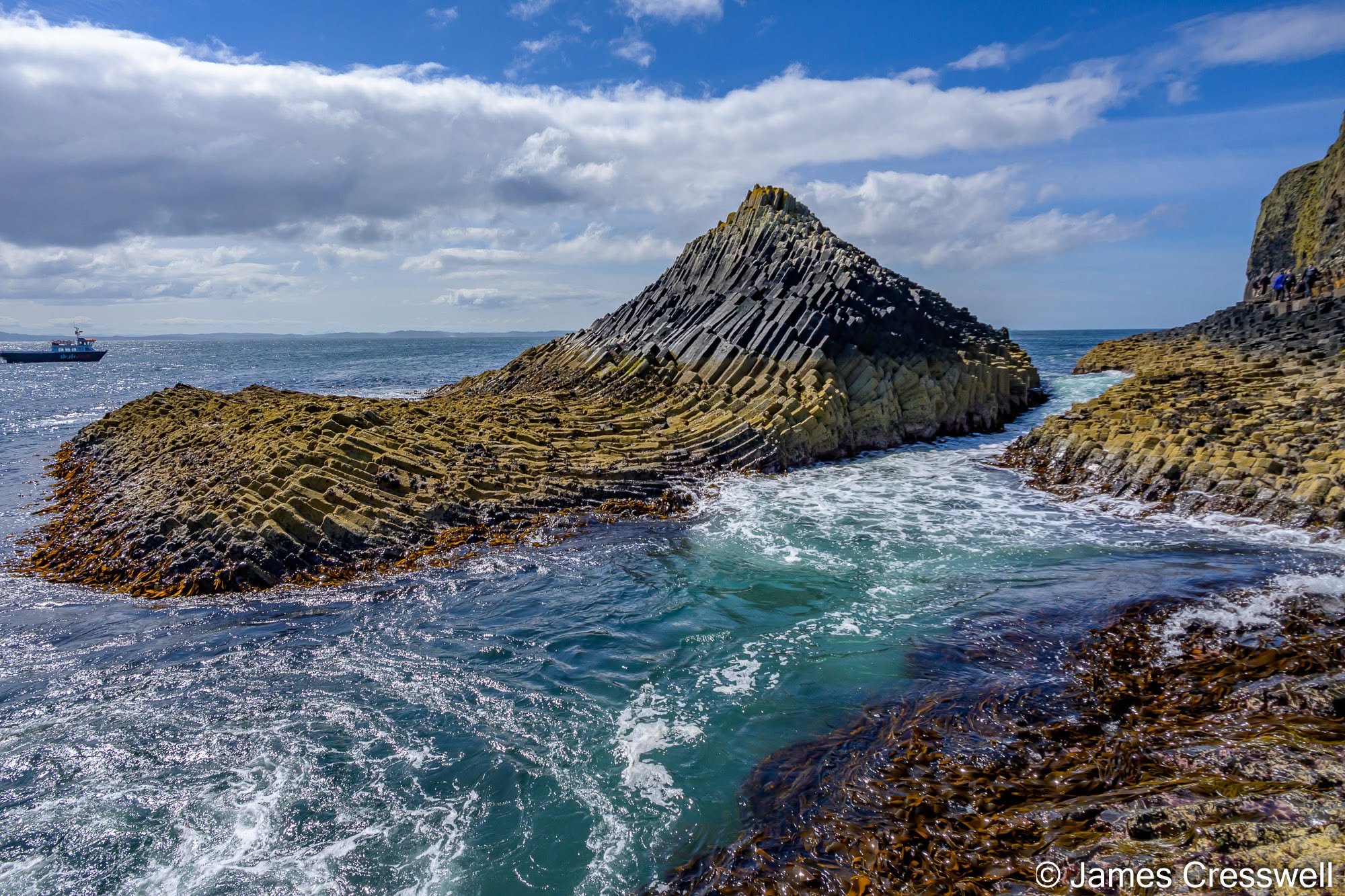
The volcanic story continued with a boat trip to Staffa and Fingal’s Cave, where the famous columnar basalt remains one of Scotland’s most striking geological sights. We also visited Lunga in the Treshnish Isles, where puffins and thousands of breeding seabirds added a wonderful wildlife element to the day.
Our final full day brought us through Lochaber, Glencoe, Loch Lomond and the Trossachs National Park, before returning to Edinburgh. Glencoe’s glaciated valley, cut into the remains of a Devonian volcano, combined dramatic scenery with both geological and human history. The tour then ended fittingly at Hutton’s Section on Salisbury Crags, where James Hutton described how dolerite had forced its way into surrounding sedimentary rocks as a sill.
This is what makes Scotland such a special GeoWorld Travel destination. It is not just beautiful, although it certainly is. It is a place where landscapes, rocks, fossils and historic discoveries come together to tell the story of how geology itself developed.
Route map of GeoWorld Travel’s ‘The Trilobites Sahara Kingdom’ tour
Day One: Arrival in Edinburgh, capital of Scotland
Our guests arrived in Scotland throughout the day, making their way to our hotel just outside Edinburgh. With easy connections from both the airport and city centre, it was the perfect place to meet before our adventure began.
After checking in, there was time to relax, get to know fellow travellers and look ahead to the incredible week ahead. Over the next nine days we’d journey through some of the world’s most important geological landscapes, from the birthplace of modern geology to ancient volcanoes, dinosaur footprints and some of Europe’s oldest rocks.
Day Two: Siccar Point, Forth Bridge World Heritage Site and Cairngorms National Park.
Our tour began with one of the most important geological sites on Earth: Siccar Point. It was here in 1788 that James Hutton recognised the immense age of our planet after observing Devonian sandstones resting on much older Silurian rocks. Standing at this famous unconformity is always a special experience, and we were fortunate to visit shortly after the opening of the new Deep Time Trail.
After lunch beside the iconic Forth Bridge World Heritage Site, we headed north towards the Highlands. Along the way we crossed the Highland Boundary Fault at Birnam, home to the famous Birnam Oak from Shakespeare’s Macbeth, before stopping at Queen’s View to admire Schiehallion, the mountain that played a key role in the first attempts to calculate the mass of the Earth. We finished the day in Aviemore, surrounded by the spectacular scenery of the Cairngorms National Park.
Left: The GeoWorld Travel group with Angus Miller at the new Deep Time Trail viewpoint above Siccar Point. The viewpoint and interpretation panels were created as part of the Deep Time Trail, completed in 2026 to mark the 300th anniversary of James Hutton’s birth. Angus and his colleagues at the Edinburgh Geological Society played a leading role in bringing this remarkable project to fruition, and we’re delighted that he’ll also be leading GeoWorld Travel’s Scotland geology tour this September..
Top right: Torsten, Carol and Neil standing on Hutton’s Unconformity at Siccar Point, arguably the world’s most important geological site. It was here, in 1788, that James Hutton recognised the immensity of geological time and laid the foundations of modern geology. The near-vertical grey Silurian (Llandovery, around 435-million-year-old) greywackes beneath their feet were originally deposited as horizontal layers within an accretionary wedge above the Iapetus Ocean subduction zone before being compressed, folded, uplifted and eroded during the Caledonian Orogeny. After a gap of around 50 million years, they were overlain by horizontal terrestrial sandstones of the Late Devonian (Famennian, around 385-million-year-old) Upper Old Red Sandstone. Both rock units were then tilted together, and Hutton realised that this entire sequence of deposition, uplift, erosion, renewed deposition and further tilting could only have taken place over unimaginably long periods of time – far longer than was widely believed in the 18th century – giving birth to the science of geology.
Bottom right: Schiehallion, viewed from Queen’s View. This distinctive 1,083 m quartzite mountain was chosen by Astronomer Royal Nevil Maskelyne for his famous 1774 experiment to measure the mountain’s gravitational attraction. By observing the tiny deflection of a plumb line, he calculated the Earth’s average density to be about 4,500 kg m⁻³—remarkably close to the modern value of 5,515 kg m⁻³—and took the first major step towards weighing the Earth. Schiehallion’s remarkably symmetrical shape, sculpted by repeated glaciations, made it an ideal natural laboratory for the experiment. The mountain also preserves an extraordinary geological story, with metamorphic rocks that were once glacial diamictites and overlying cap carbonates, recording the Cryogenian “Snowball Earth” glaciations around 720 million years ago.
Left: Looking southwest along the length of Loch Ness. At 37 km (23 miles) long and up to 230 m deep, it is the largest lake by volume in the UK, containing more water than all the lakes in England and Wales combined. The loch occupies a glacially overdeepened valley carved by ice along the Great Glen Fault, one of Britain’s most important geological structures. This major sinistral strike-slip fault separates the Grampian Terrane from the Northern Highland Terrane and accommodated hundreds of kilometres of movement, principally during the final stages of the Caledonian Orogeny around 430–400 million years ago. The fault extends southwest into Ireland, Newfoundland and the Gulf of St Lawrence, and northeast to Shetland, where it continues as the Walls Boundary Fault.
Right: A fossil fish discovered by Hugh Miller, on display at the Hugh Miller Museum in Cromarty. Born in 1802, Miller was one of the great Scots of the 19th century—a geologist, writer and folklorist whose pioneering work transformed our understanding of Scotland’s geology. Despite having no formal academic training, he became one of the country’s foremost palaeontologists, discovering numerous Devonian fossil fishes, including this specimen of Pterichthyodes milleri, together with Silurian sea scorpions. His contributions to geology were so significant that the eurypterid Hughmilleria, the placoderm Millerosteus and the BP-operated Miller Oilfield in the North Sea were all named in his honour.
Left: Carol reading the interpretation panels at the Ferrycroft Visitor Centre in Lairg. The centre explains the proposed Lairg impact structure and the geological detective work that led to its discovery. For many years, geologists recognised a large gravity anomaly beneath Lairg but were unable to explain its origin. The discovery of impact ejecta along the nearby coast, together with geophysical studies, has led to the proposal that the anomaly represents the deeply buried remains of a meteorite impact crater around 40 km in diameter, now concealed beneath rocks carried westwards by movement along the Moine Thrust. More recent research has also identified a second gravity anomaly beneath The Minch, and the relationship between the two structures continues to be investigated
Right: Mullions developed within metamorphosed Morar Group rocks beneath Oykel Bridge. Mullions are linear structures formed during deformation, where contrasting rock layers respond differently to intense compression during mountain building. This stop also provided an opportunity to discuss the recent reinterpretation of the Moine Supergroup, which has significantly changed our understanding of the geological evolution of the Scottish Highlands.
Left: John at the Moine Thrust, Knockan Crag. This is one of the world’s most important geological sites, where the Moine Thrust was first recognised and correctly interpreted, transforming our understanding of mountain building. Here, metamorphic rocks of the Neoproterozoic Morar Group have been thrust westwards over much younger Cambrian rocks during the Scandian phase of the Caledonian Orogeny. This relationship challenged 19th-century geologists because it appeared to overturn the Law of Superposition, which states that younger rocks should overlie older ones. The solution lay in recognising that enormous horizontal movements along thrust faults can carry older rocks on top of younger ones.
Right: The GeoWorld Travel group at the Moine Thrust, Knockan Crag. This National Nature Reserve, within the North West Highlands UNESCO Global Geopark, is one of the world’s most important geological sites, where the recognition of large-scale thrust faulting resolved the famous “Highlands Controversy” and transformed our understanding of mountain building.
Day Three: Loch Ness and the North West Highlands
The day began beside the famous waters of Loch Ness, which occupies part of the Great Glen Fault. While some kept an eye out for Nessie, we explored the geological forces that shaped Britain’s largest body of freshwater by volume.
Travelling via Inverness, we visited Cromarty to learn about the remarkable life of Hugh Miller, one of Scotland’s most celebrated geologists and palaeontologists. From there we continued to Ferrycroft Visitor Centre to discover the fascinating story of the enormous meteorite impact buried beneath Lairg.
The afternoon was spent at Knockan Crag in the North West Highlands Geopark. Here we explored the Moine Thrust, the world’s first recognised thrust fault, and one of the discoveries that transformed geological understanding. After a full day in the field we arrived in the picturesque fishing town of Ullapool for a well-earned evening.
Left: The Stronechrubie Cliffs expose Cambrian and Ordovician carbonates of the Durness Group. At Knockan Crag, most of the displacement is concentrated on the Moine Thrust itself, but north of there the deformation becomes distributed across several thrust faults. Here, movement is shared between the Moine Thrust, the Sole Thrust and numerous smaller imbricate thrusts, producing the stacked slices of dolostone visible in the upper cliffs. This locality demonstrates how a major thrust zone can split into many individual faults while accommodating the same overall movement.
Top Right: YiLing and Adelene at the Glencoul Thrust. This is one of the classic localities of the North West Highlands, where the Ben More Thrust has carried 3-billion-year-old Lewisian gneiss over Cambrian sedimentary rocks, which themselves rest unconformably on an older surface of Lewisian gneiss below—creating a “Cambrian sandwich”. It is another spectacular demonstration of the enormous horizontal movements that took place during the Caledonian Orogeny.
Bottom Right: Jen standing in front of one of the most striking geological outcrops in the Scottish Highlands. This road cutting records three distinct episodes in the Earth’s history. The oldest rocks are the pink and grey Lewisian tonalitic gneisses, formed around 3 billion years ago. These were later cut by dark Scourie dolerite dykes about 2.4 billion years ago, which were subsequently metamorphosed into amphibolite. Finally, all of these rocks were cut by pale granitic pegmatite dykes during the Laxfordian event around 1.85 billion years ago. It is a remarkable example of how one outcrop can preserve over a billion years of geological history.
Left: Adelene pointing to the unconformity between the 3-billion-year-old Lewisian Gneiss and the overlying 1-billion-year-old Torridon Group. This surface represents an extraordinary gap in Earth’s history, with around 2 billion years—or more than 20% of the Earth’s history—missing at the unconformity. Above Adelene, the Torridon Group forms alternating beds of massive sandstone and coarse conglomerate, while below the unconformity lies the deeply weathered Lewisian Gneiss.
Right: Suilven, one of Scotland’s most iconic mountains, viewed across the Assynt Foreland—a billion-year-old erosion surface that is once again exposed at the Earth’s surface. In 2014, the Assynt Foreland was voted the top geosite in the UK and Ireland in the Geological Society’s public vote. Suilven is formed from Torridon Group sandstones, deposited by rivers in a foreland basin in front of the rising Grenville Mountains during the assembly of the supercontinent Rodinia. These 1-billion-year-old sandstones rest unconformably on a foundation of 3-billion-year-old Lewisian Gneiss.
Left: The GeoWorld Travel group pointing to a mudstone dyke injected into the famous Clachtoll Boulder. Believed to be the world’s largest known landslide boulder, this enormous block of 3-billion-year-old Lewisian Gneiss crashed onto water-saturated sands around 1.2 billion years ago as the Stoer Group was being deposited. The impact liquefied the wet sediment beneath the boulder, forcing mud upwards into fractures within the gneiss to form the remarkable injection dykes visible today.
Right: A beach pebble of the 1.2-billion-year-old Stac Fada Member containing green impact glass (often referred to as tektite) produced by a meteorite impact. The Stac Fada Member also contains shocked quartz, providing some of the strongest evidence that these deposits were formed by a giant impact. The source crater is thought to be the large buried structure beneath Lairg, whose gravity anomaly we visited the previous day. The Stac Fada Member forms part of the Stoer Group, deposited around 200 million years before the younger Torridon Group.
Left: Jurassic sandstones at Elgol, on the Isle of Skye. At the base of the cliff, the sandstone displays the distinctive honeycomb weathering for which Elgol is well known. Cutting across the cliff are Palaeogene basaltic dykes, intruded during the volcanic activity that built the Skye Igneous Centre around 60 million years ago. One dyke changes orientation as it crosses the cliff, illustrating how magma exploited different fractures as it forced its way through the Jurassic rocks.
Right: Sgùrr na Strì, part of the Black Cuillin, viewed across Loch Scavaig from Elgol. Although the higher Cuillin ridge was hidden by cloud, this lower peak was clear. The mountain is composed mainly of olivine-bearing gabbro, historically known as eucrite, belonging to the Cuillin Igneous Centre. It is cut by numerous Palaeogene dykes, and the pale line descending the mountain appears to follow a zone of weakness, possibly controlled by dykes or fractures.
Day Four: Ancient Rocks of the North West Highlands
Today was a journey through almost three billion years of Earth history. Throughout the North West Highlands we explored thrust faults, classic Cambrian rock sequences and spectacular unconformities that reveal Scotland’s complex geological past.
We examined some of Britain’s oldest rocks around Scourie and Laxford Bridge, including the famous Lewisian Gneiss, before seeing the colourful Laxfordian rocks and ancient Scourie Dykes. After lunch we visited the dramatic Assynt landscape, voted the UK’s number one geosite, before continuing to Stoer to see evidence linked to the ancient Lairg meteorite impact.
With incredible scenery accompanying every stop, it was another unforgettable day before returning to Ullapool.
Left: The GeoWorld Travel group at the Quiraing, one of Scotland’s most spectacular landscapes. The Quiraing is the largest landslide in Britain, extending over 2 km in width and covering approximately 8.5km² on the eastern flank of the Trotternish Ridge. Here, a 300-metre-thick pile of Palaeogene basalt lava flows rests on weaker Jurassic mudstones, sandstones and limestones. Following the last Ice Age, removal of glacial support destabilised the escarpment, allowing huge blocks of basalt to rotate and slide seawards. Some parts of the landslide remain active today, requiring regular road repairs.
Top right: Torsten points to a Middle Jurassic dinosaur footprint at Duntulm on the Isle of Skye. The Duntulm Formation (Bathonian, around 168 million years old) preserves one of the most important Middle Jurassic dinosaur tracksites in the world, a time from which dinosaur fossils are exceptionally rare. The footprints were made by sauropod dinosaurs walking across the soft sediments of a coastal lagoon, where the mud was firm enough to record their tracks but still waterlogged enough to preserve remarkable details, including toes, claw marks and complete trackways. These fossils provide some of the best evidence anywhere that primitive long-necked sauropods were still thriving during the Middle Jurassic.
Bottom right: The GeoWorld Travel group examines a theropod dinosaur footprint at An Corran on the Isle of Skye. Together with the nearby Duntulm tracksite, An Corran has helped establish Skye as one of the world’s most important localities for Middle Jurassic dinosaurs.
Left: Kilt Rock on the Trotternish Peninsula. The cliffs display a spectacular geological sandwich, with flat-lying Middle Jurassic sedimentary rocks enclosed between two resistant Palaeogene olivine dolerite sills. The upper sill forms the sheer cliffs of Kilt Rock, while a second sill can be seen at sea level. As the dolerite cooled, it contracted to produce the striking vertical columnar joints that dominate the cliff face. The Jurassic sandstones and mudstones between the two sills have yielded dinosaur footprints, bones and other fossils.
Right: Caroline Ross explains the exhibits to the GeoWorld Travel group inside the Staffin Dinosaur Museum. The museum was founded in 1976 by her father, Dugald (“Dougie”) Ross, while he was still a teenager. Over the following five decades, Dougie discovered, collected and documented dinosaur footprints, bones and other fossils from across the Isle of Skye, making a major contribution to our understanding of Scotland’s Jurassic past. Following his death in 2025, Caroline continues his work by welcoming visitors and sharing the story of Skye’s dinosaurs.
Left: A Middle Jurassic theropod dinosaur footprint on display in the Staffin Dinosaur Museum. The Isle of Skye preserves some of the best Middle Jurassic dinosaur tracksites in the world.
Right: A small sauropod footprint at the BP2 tracksite, Rubha nam Brathairean (Brothers’ Point), Isle of Skye. Brothers’ Point contains three separate dinosaur tracksites (BP1, BP2 and BP3), recording footprints of sauropods and bipedal dinosaurs, and additionally yielding a pterosaur fossil. This footprint comes from BP2, where 49 footprints, mostly from small sauropods preserved in two distinct trackways, were formed in soft lagoonal sediment around 167 million years ago. The three toe impressions and fleshy heel pad are clearly visible.
Day Five: Into the Heart of Skye
Leaving Ullapool behind, we travelled south towards the Isle of Skye, stopping first at the impressive Corrieshalloch Gorge before pausing for views of the iconic Eilean Donan Castle.
After crossing onto Skye we made our way to Elgol, where a boat trip carried us across Loch Scavaig into the spectacular setting of Loch Coruisk beneath the towering Black Cuillin. These mountains represent the deeply eroded roots of an ancient volcano formed during the opening of the Atlantic Ocean around 55 million years ago.
With layered gabbros, glacial scenery and the chance to spot seals, this was one of the visual highlights of the tour before finishing the day in Portree.
Top left: The Old Man of Storr, one of Scotland’s most recognisable geological landmarks, is part of the 30 km-long Trotternish Landslide Complex, the largest mass movement landslide in Britain. Around 300 metres thick of Paleogene basalt lava flows overlie weaker Jurassic sedimentary rocks, and after the last Ice Age the volcanic pile collapsed along a series of rotational landslides. The Old Man itself is an isolated pinnacle left behind as one of these detached blocks.
Top right: An Atlantic puffin (Fratercula arctica) on the Isle of Lunga in the Treshnish Islands. Lunga supports one of the largest Atlantic puffin colonies in the British Isles, where thousands of birds return each spring to breed in burrows dug into the island’s grassy slopes.
Middle right: An Atlantic puffin (Fratercula arctica) carrying two sand eels back to its burrow on the Isle of Lunga in the Treshnish Islands. Puffins use the spines on the roof of the mouth and a specialised hinge mechanism in the bill to hold several fish at once while continuing to catch more for their chick.
Bottom: An Atlantic puffin (Fratercula arctica) resting on 60-million-year-old Paleogene basalt lava flows on the Isle of Lunga in the Treshnish Islands. These volcanic rocks were erupted from the Mull volcanic centre during the opening of the North Atlantic.
Day Six: Dinosaurs of the Isle of Skye
Today combined spectacular scenery with one of Scotland’s most exciting fossil stories.
Our morning took us around the dramatic Trotternish Peninsula, including the famous Quiraing landslip, before visiting the Staffin Dinosaur Museum. We were delighted to meet Dugie Ross, whose discoveries have helped establish Skye as one of the world’s finest locations for Middle Jurassic dinosaur footprints.
Later we visited Brothers’ Point, where the footprints themselves can still be seen preserved within the rocks, before stopping at Kilt Rock and passing beneath the famous Old Man of Storr as we made our way south. After crossing back to the mainland by ferry, we spent the evening in Lochaber.
Left: Columnar basalt at the landing stage on the Isle of Staffa. These spectacular hexagonal columns formed as Paleogene basalt lava cooled and contracted around 60 million years ago. The fan-shaped pattern almost resembles a folded syncline, but the lava has not been deformed. Instead, the lava flowed over an uneven landscape, so the cooling surfaces were curved rather than horizontal, causing the columns to develop in different directions.
Right: Looking into Fingal’s Cave. The cave has been excavated by Atlantic waves within a 50 m-thick Paleogene basalt lava flow erupted from the Mull volcano around 60 million years ago. The spectacular hexagonal columns formed as the lava cooled and contracted. The prominent fracture zone visible in the roof probably represents a major joint or fault that provided a line of weakness, helping to guide the development of the cave.
Left: Some of the GeoWorld Travel group at the entrance to Fingal’s Cave. Carved by Atlantic waves into a 50 m-thick basalt lava flow erupted from the Mull volcano around 60 million years ago, Fingal’s Cave is one of the world’s finest examples of columnar basalt. The remarkable hexagonal columns formed as the lava cooled and contracted, while wave erosion gradually enlarged natural fractures to create the cave we see today.
Top right: Fingal’s Cave, Isle of Staffa. The cave has been excavated into a 50 m-thick basalt lava flow erupted from the Mull volcano around 60 million years ago. The spectacular lower colonnade formed as the interior of the thick lava flow cooled slowly, while the irregular entablature above developed where cooling was much more rapid, probably as water penetrated the flow. Beneath the columns, bedded volcaniclastic deposits record a quieter interval between volcanic eruptions before the lava was emplaced.
Bottom right: Looking across to Ben Hiant. Around 60 million years ago, as the North Atlantic began to open, basalt lava flows from the Mull volcano—the same volcano that produced the lava flows of Fingal’s Cave—spread across this landscape, forming the lower slopes of the mountain. The summit, however, belongs to the younger Ardnamurchan volcano and represents one of its three recognised eruptive centres. Ben Hiant therefore preserves rocks from two different volcanoes within the North Atlantic Igneous Province.
Day Seven: Fingal’s Cave and Puffins
Another boat trip awaited us today as we travelled from Kilchoan to the remarkable island of Staffa.
Fingal’s Cave never fails to impress, with its perfectly formed columns of basalt creating one of Scotland’s most recognisable natural landmarks. We also visited the island of Lunga, where puffins, guillemots and thousands of nesting seabirds provided an unforgettable wildlife experience.
Back on the mainland we explored the ancient Ardnamurchan volcano before returning to Acharacle for our second evening.
Top left: The Ballachulish Slate began as mud deposited in deep water along the eastern continental margin of Laurentia as Rodinia began to fragment, forming part of the Dalradian Supergroup around 800 million years ago. During the Caledonian mountain-building event it was buried, folded and metamorphosed, producing the distinctive slaty cleavage that made Ballachulish one of Scotland’s most important roofing slate quarries. The slate is cut by an igneous dyke, which may date either from the Caledonian Orogeny or from the much younger Palaeogene volcanic activity associated with the opening of the North Atlantic.
Top right: A lone piper plays beneath the Three Sisters of Glen Coe. The spectacular U-shaped valley was carved by glaciers during the Ice Age, but the mountains themselves are the remnants of the 420-million-year-old Glencoe Caldera volcano. The cliffs expose alternating rhyolite lava flows and ignimbrites (welded volcanic ash deposited by pyroclastic flows), with the Three Sisters formed from two ignimbrite units separated by two rhyolite lava flows, all resting on the Basal Andesite Sill.
Day Eight: Glencoe and Return to Edinburgh
Our final full day took us through some of Scotland’s most iconic landscapes.
After crossing Loch Linnhe we visited Ballachulish Slate Quarry before entering the magnificent valley of Glencoe. Here we explored the remains of an ancient Devonian volcano, dramatic glacial scenery and the tragic history of the Massacre of Glencoe.
Travelling south through Loch Lomond and the Trossachs National Park, we paused at the Falkirk Wheel before returning to Edinburgh. Fittingly, our final geological stop was Hutton’s Section at Salisbury Crags, where James Hutton demonstrated how molten rock had intruded surrounding sediments, another discovery that helped shape modern geology.
Top left: Members of the GeoWorld Travel group at the Sir Hugh Munro Memorial Cairn at the Loch Tulla viewpoint. The cairn, completed in 2000, was built from 795 stones collected from every Munro and Munro Top recognised at the time, commemorating Sir Hugh Munro, who first compiled the Munro Tables in 1891.
Top right: Hutton’s Section at the base of Salisbury Crags, Edinburgh. Here, a Carboniferous dolerite sill was intruded into older Carboniferous sandstone, producing the distinctive upturned lip of sedimentary rock seen in the photograph. This outcrop provided James Hutton with key evidence that molten rock had been injected into older strata, helping to establish the igneous origin of intrusive rocks and laying the foundations of modern geology.
Middle right: Members of the GeoWorld Travel group in Holyrood Park, Edinburgh. The outcrop on the right is volcanic vent agglomerate from the Carboniferous Arthur’s Seat volcano, while behind the group lies the Salisbury Crags dolerite sill, famous for Hutton’s Section. In the distance, Edinburgh Castle stands on the volcanic plug of a second Carboniferous volcano.
Bottom: Edinburgh Castle perched on Castle Rock, the eroded volcanic plug (or feeder vent) of an Early Carboniferous volcano. The magma cooled within the volcanic conduit to form hard dolerite, a coarse-grained equivalent of basalt. During the Ice Age, glaciers stripped away the surrounding softer sedimentary rocks, leaving the resistant volcanic plug standing high above the city as the classic ‘crag’ of Edinburgh’s famous crag-and-tail landform.
Day Nine: Farewell Scotland
After breakfast our tour officially came to an end.
Many guests travelled home, while others stayed on to explore more of Edinburgh, itself a UNESCO World Heritage Site built across ancient volcanic landscapes. From Edinburgh Castle to Arthur’s Seat, the city provides the perfect finale to a journey through Scotland’s extraordinary geological heritage.
We left with fantastic memories, wonderful company and an even greater appreciation for one of the world’s great geological destinations.
We have so many great memories from this most recent tour, and we are already looking forward to returning in September.
Our September 2026 Scotland tour is currently full, but a waitlist is available. If you would like to join us on a future Scotland journey, please do register your interest.
For information on our other tours, visit our Destinations Page.