
Set against the backdrop of the Atlantic Ocean’s volcanic giants, our Canary Islands adventure was a nine-day immersion into some of Europe’s most dramatic natural landscapes. From Tenerife’s towering Teide to La Gomera’s lush World Heritage forests and La Palma’s fresh volcanic flows, this trip blended awe-inspiring geology with warm winter sunshine and unforgettable group moments. Across three remarkable islands, we hiked crater rims, wandered along lava fields, crossed ocean channels by ferry, and came away with a deeper appreciation of Earth’s fiery story.
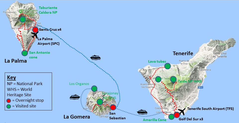
Route map of GeoWorld Travel’s ‘Volcanic Island Hopping’ tour
Day One: Arrival on Tenerife and Welcome Dinner
Settling in at El Médano and kicking off with a group dinner to meet the crew and set the tone for the week ahead
Day Two: Exploring Tenerife’s Volcano Heart: Chinyero to Teide
A full day discovering volcanic cones, lava flows, and the awe-inspiring slopes of Mount Teide.
Left: The GeoWorld Travel group standing on the youngest lavas on Tenerife. These erupted in 1909 from the Chinyero cone, which lies hidden, just behind the trees.
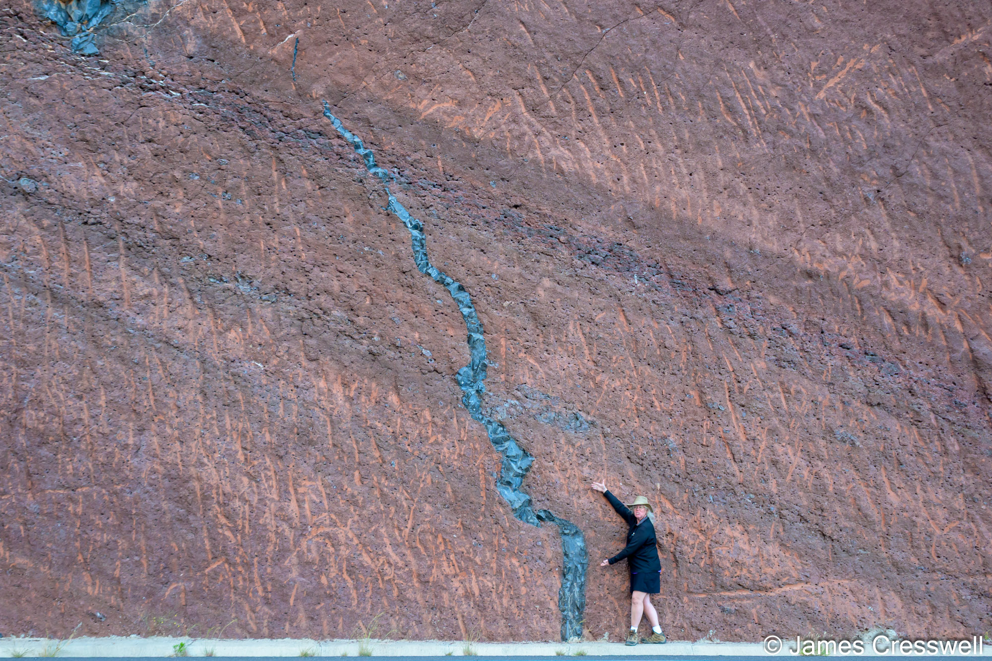
Top right: A photo of two different lava flows which have two different chemistries, sitting one on top of the other. What makes this particularly interesting is that the lava erupted from the same volcano, possibly even the same single eruptive event (or, at least, two very closely spaced eruptions). The bottom layer is basanite and it sits on a basement of baked red lapilli. The top layer is phonolite, which contains basanite enclaves demonstrating that the two magma types were in the process of mixing together to form an intermediate magma, but this mixing process was most likely interrupted by the eruption.
Bottom right: The GeoWorld Travel group at the Mirador de Chahorra. Behind them is Pico Viejo, a parasitic cone of the central Teide volcano. The dark colour visible on the side of the cone is lava which erupted from a 1.2km long radial fracture in 1798AD. The eruption lasted three months and six days and the lava flow, which ponded 15-20m (49-65ft) deep in places, was contained by the western caldera wall.
Left: Dyke intrusions (ring-type dykes, radial dykes, and cone sheets) exposed in the wall of the Caldera de Las Cañadas at Boca de Tauce.
Right: Los Azulejos is a colourful outcrop on the inner wall of the Las Cañadas caldera. Its secondary colours, including pale-blue, green, yellow and rusty bands, are due to fault-controlled hydrothermal alteration. The rocks exposed here were originally light-coloured, feldspar-rich phonolitic lavas and pyroclastic deposits (that is, material related to the phonolitic stage of Tenerife volcanism). Subsequent circulation of hot, acidic fluids changed the primary minerals (especially feldspars) into clays and secondary minerals (chlorites, micas, zeolites, adularia and epidote), producing the distinct colour bands.
Left: Roque Cinchado, an erosion remnant that resisted weathering and denudation. The hard rock of the younger sills have slowed erosion, whereas surrounding rock has been more efficiently eroded away. The Roque Cinchado has experienced greater erosion at its softer base. In the background, the summit of Teide Volcano is visible.
Right: A viscous phonolite flow suspended mid-slope. Lava, in contrast to water (a Newtonian fluid), is a non-Newtonian (Bingham) fluid that requires overcoming a yield stress to flow. If this stress decreases (e.g. if the lava stops flowing from the vent or if cooling is efficient), then a lava flow or tongue can become arrested even on steep slopes, as seen in the photograph.
Left: Phonolite obsidian seen at San Jose pumice quarry. This obsidian lava flow was emitted from the summit of Teide around 600-900AD.
Right: The San Jose pumice quarry. This is an area where pumice used to be mined for lightweight concrete, abrasives, toothpaste, hand cleansers and body scrubs. The mining was suspended in the 1970’s due to the heavy environmental impact. This pumice erupted 2,000 years ago in a sub-Plinian eruption from a phonolite dome called Montaña Blanca. This was the only large eruption in Teide’s 4th cycle.
Day Three: Tenerife’s Amarilla & Caldera del Rey, Then Ferry to La Gomera
A final Tenerife geological tour before crossing to lush La Gomera by ferry.
Left: The GeoWorld Travel group starting the ascent to the summit of Mt Teide (at 3,718m) from the Upper Cable Car Station at 3,555m. The path leads across a phonolite lava flow.
Top right: Becky standing on the summit of Mt Teide (3,718m). To the right of Becky is the Teide summit crater, whilst in the mid-ground is the wall of the Las Cañadas caldera which formed when the Las Cañadas volcano (an ancestral Teide) collapsed and fell into the ocean, 200,000 years ago. In the far distance, behind Becky, is the island of Gran Canaria.
Bottom right: A view of the summit of Mt Teide and the Upper Cable Car Station from inside the cable car on our descent.
Left: Nick standing on a ‘fossilised’ beach sand dune the base of the Amarilla Cone. This is a phreatomagmatic tuff cone which formed around 1 million years ago. It is morphologically different to other tuff cones on Tenerife because the initial eruption was rich in seawater before evolving into a subaerial strombolian eruption. The name of the volcano, Mña Amarilla, means Yellow Mountain; it is yellow because of palagonite tuff which has formed due to the seawater hydrating the volcanic ash.
Right: The GeoWorld Travel group standing on a ‘fossilised’ beach sand dune at the Amarilla Cone. The marine sand was blown against the volcano cliff when sea levels were lower. These beach dunes show horizontal and cross-bedding. They contain the odd fossil and even have pieces of pumice in them that would have been washed up on the fossilised beach. Fossils that have been found include red algae, marine gastropods and sea urchins. The pumice may have come from the eruption of Caldera del Rey or a submarine El Hierro eruption.
Left: An erosional channel near the base of Mña. de Guaza which is filled with pyroclastic flow deposits (likely from Guaza) and with fall deposits from Caldera del Rey.
Right: Adeje ignimbrite (orange-red) is unconformably overlain by the San Juan pale cream ignimbrite. Allen is pointing here at obsidian fragments preserved in the Adeje ignimbrite. Ignimbrites are deposits created by pyroclastic flows. Both of these flows were emitted from Las Cañadas volcano, which existed before Teide formed.
Left: Basaltic dyke (taparucha), up to 5m thick and several kilometres long, that intruded the Miocene basalts near Los Chejelipes, in Bco. de la Villa, above San Sebastian de la Gomera, on the island of La Gomera.
Right: Becky points to a basaltic dyke which cuts through a red-coloured rock in a former quarry on La Gomera. The red rock is made of lapilli-sized (2-64mm diameter) fragments of scoria (a volcanic rock rich in gas bubbles). These volcanic fragments would have fallen from the air during a volcanic eruption forming beds. These beds were subsequently buried under Miocene basalt flows and then experienced ‘burial metamorphism’, which baked them into a solid rock.
Day Four: Garajonay National Park and La Gomera’s Rugged Interiors
Misty forests, towering rock formations, and the dramatic landscapes of Garajonay World Heritage Site.
Left: Los Organos, on the northern coast of La Gomera, is a large trachytic dome. Erosion has removed half of the dome, thus exposing an internal structure of vertical columnar joints know widely as ‘Los Organos’ (the organ pipes).
Top right: Los Organos, on the northern coast of La Gomera, is a large trachytic dome. Erosion has removed half of the dome, thus exposing an internal structure of vertical columnar joints know widely as ‘Los Organos’ (the organ pipes).
Bottom right: The village of Alojera (on La Gomera) in the foreground, with pale coloured dykes visible cutting through Miocene-aged lava layers in the mid-ground.
Left: The view from Mirador de la Curva del Queso, where a major unconformity can be seen. Seaward dipping Miocene basalts in the lower valley are overlain by sub-horizontal Pliocene basalts. A major period of erosion happened between the two lava flows; this lasted for 2-3 million years.
Right: A walk in the forest in Garajonay National Park, which was declared a national park in 1981 and a World Heritage Site (WHS) by UNESCO in 1986. It occupies 40 km2 (15 sq mi). The park provides the best example of Canarian laurisilva, a humid subtropical forest that in the Tertiary covered almost all of Southern Europe. It is also found on the Azores and the Madeira Islands. Laurus azorica, known as Azores laurel or Macaronesian laurel, can be found in the park, as well as Laurus novocanariensis, known as Canary laurel.
Left: A view of Roque de Agando trachyte dome, which is 5.1 million years old. This rock was once a much larger spherical shape, indicated by the “onion skin” cooling joints which suggest that that this dome was significantly larger before erosion (or collapse) of its southern flank.
Right: Local guide Janin holds up an image of an erupting vent of the Tajogaite volcano, which formed on La Palma in 2021. The same vent is behind her in the photograph.
Day Five: Into La Palma’s New Lava Landscapes
Hiking around the recently erupted Tajogaite volcano and exploring lava tubes and rugged fields.
Top left: Eruptive craters of the newly formed Tajogaite volcano which was created in 2021
Top right: The area around the summit of the 2021 Tajogaite volcano is still a restricted area and it is only possible to go inside this are with a registered local guide.
Middle right: The GeoWorld Travel group descending into the Caños de Fuego lava tubes, La Palma. These lava tubes, which can only be visited with a local registered guide, occur in lava that erupted in 1949.
Bottom: The GeoWorld Travel group inside the Caños de Fuego lava tubes, La Palma. Lava tubes form when the surface of a flowing lava stream cools and solidifies into a crust while the hotter, still-molten lava continues to flow beneath it and later drains away leaving a hollow tunnel.
Left: A view of the Teneguia volcano which formed in 1971. Up until 2021, when the Tajogaite volcano formed, this was the youngest volcano on La Palma.
Right: A view into the San Antonio Volcano, La Palma. Contrary to popular belief, the San Antonio Volcano didn’t form in 1677. It formed more than 3,000 years ago, but in 1677 there was another smaller eruption around the older pre-existing cone, which confused the initial dating process.
Left: Salt pans near the Fuencaliente Lighthouse on the southern tip of La Palma.
Top right: A view of the San Antonio Volcano from the Mirador Los Espigones
Bottom right: Keith standing beside 1712 basanite lava flows at El Remo, La Palma. The flow here is a deep flow channel, 50m (164ft) wide, bounded by enormous levees 10m (32.8ft) high.
Day Six: La Palma’s Volcanoes, Lava Flows and Coastal Views
From ancient San Antonio flows to the Teneguia eruption and coastal lava deltas.
Top left: A rainbow above the Barranco de las Angustias, seen from Mirador de Cancelita on La Palma.
Top right: A view of La Caldereta as seen from the Mirador de La Concepción. The impressive tuff cone of La Caldereta is composed of highly compacted yellow (palagonitic) tuffs and has a base measuring approximately 1.5km (0.93 miles) and a crater diameter of 1km (0.62 miles). It is therefore among the largest tuff cones in the Canary Islands. Initially the magma interacted with seawater, but was subsequently isolated from the sea water, changing the eruptive style from hydrovolcanic to Strombolian.
Middle right: A view of Mt Teide on Tenerife, taken from a site near the highest point of neighbouring La Palma. The volcano has an unusually large amount of snow on it, due to its largest snowfall for six years occurring a few days previously.
Bottom right: The GeoWorld Travel group and numerous telescopes(!) near the highest point on the islands of La Palma, the Roque de Los Muchachos Astrophysical Observatory.
Bottom middle: The view from Roque de Los Muchachos, the highest point on the island of La Palma.
Bottom left: The summit of Bejenado Volcano seen emerging through the clouds from Roque de Los Muchachos, La Palma. The volcano formed approximately 560,000 years ago, after the giant Taburiente landslide, and forms the southern perimeter of the Taburiente Caldera.
Day Seven: The Caldera de Taburiente: Calderas, Gorges and Geological Time
A day of spectacular hikes and panoramic views inside one of the Canary Islands’ great calderas.
Day Eight: Summit Views and Astronomical Perspectives at Roque de los Muchachos
High-elevation panoramas and cloud phenomena atop La Palma’s crater rim, with astronomy highlights.
Day Nine: Farewells and Final Reflections
Wrapping up the journey with goodbyes and memories as the group heads home or extends their stay in the Canaries.
—————————
Thank you to those who joined us on the tour to make this another enjoyable and memorable trip to the Canaries.
We will be returning to the Canary Islands again in 2026, so please keep an eye on our website (Here) for further details of future trips.
