GeoWorld Travel returned to the Alps in July 2024 for a third time, with another “Alpine Adventure” tour. The circular trip, starting and ending in Geneva, gave our guests the opportunity to take in the breath-taking scenery that Switzerland has to offer, and to understand the geological stories and science behind the formation of this stunning landscape. The photos below tell the story of our adventure…
Day One: Geneva
Our group assembled at a Geneva Airport hotel, having made their way from the UK, the USA and Australia! All thirteen guests enjoyed the chance to meet in person and to start to get to know each other at a group meal in a local restaurant on the first evening. After the meal, everyone headed back to the hotel for a good night’s rest before the first full touring day.
Day Two: Geneva – Neuchâtel
Top left: Creux-du-Van, located in the Jura Mountains, is a natural rocky cirque – a glacially eroded, horseshoe-shaped limestone cliff of enormous proportions. It is sometimes referred to as the ‘Grand Canyon of Switzerland’.
Top right: Pierre à Bot, a glacial erratic made of granite which originated in the Mount Blanc massif and was carried to its present position in the last Ice Age. Switzerland’s most famous geologist, Louis Agassiz, used it to defend his theory of glaciation.
Bottom left: The GeoWorld Travel group inspecting some cobble stones in the streets of Neuchâtel. These cobble stones include both locally derived limestone and also ophiolitic rocks, which would have been carried by glaciers all the way from the Zermatt region.
Bottom right: An exhibition of recently-found Plateosaurus remains in the Muséum d’Histoire Naturelle, Neuchâtel, on loan from the Sauriermuseum in Frick. These are some of the very few dinosaur remains to have been found in Switzerland.
Day Three: Neuchâtel – Jungfraujoch – Interlaken
Clockwise from top left: The GeoWorld Travel group at Eigergletscher Station, on the way up to the Jungfraujoch. Trains run from Eigergletscher to the summit of the Jungfraujoch, through the 7,122m (23,366 ft) long Jungfrau tunnel, and it is one of the highest railways in the world.
A view of the Aletsch Glacier, the longest and largest glacier in the Alps and the showpiece of the Jungfrau-Aletsch UNESCO World Heritage site.
Some of our group at the ‘Top of Europe’, on the Jungfraujoch, at 3,463m (11,362ft) above sea level.
Photo taken inside the Ice Palace at the Jungfraujoch. The black line is a dirty, sediment-rich layer within the ice.
View from the window at the Eismeer station, looking at the Eischmeer Glacier from within the Eiger Mountain, on the rail journey up from Eigergletscher to Jungfraujoch.
The group enjoying the descent from Jungfraujoch in the Eiger Express gondola!
Day Four: Interlaken – Glarus – Lochsite – Klausenpass
Clockwise from top left: Martinsloch (Martin’s Hole) is a rock ‘window’ which is 17m tall and 19m wide, located at some 2,600m above sea level in the Tschingelhorn mountain. This view shows both the Glarus Thrust and Martin’s Hole.
The group enjoying a picnic lunch at the Glarus Thrust in the Swiss Tectonic Arena Sardona UNESCO World Heritage Site. This is a globally important geosite, and it is the birthplace of the understanding of nappes.
View across Lake Lucerne with the Stanserhorn on the left and Pilatus on the right. Pilatus is made of Cretaceous-aged sedimentary rock and is part of the Helvetic nappes, while the rocks that form the Stanserhorn are part of the Penninic nappes which have thrust over the whole area.
Impressive folding within the Helvetic nappes (rocks that formed in the shallow seas on the southern margin of Europe) at Klausenpass.
The GeoWorld Travel group examine a glacial erratic near Schywz. In the background a thrust fault can be seen.
View of the Mythen from Schwyz. The Mythen is formed of two peaks, Kleiner Mythen (1,811 m) and Grosser Mythen (1,898 m). The mountain is made up of rocks from the Penninic nappes (rocks that formed in the ocean between Europe and Africa). The differential erosion of the easily erodible Middle Jurassic and Triassic strata and the massive Late Jurassic limestones is the cause for the notch in Kleiner Mythen and the saddle between Kleiner and Grosser Mythen.
Day Five: Klausenpass – Rhône Glacier – Aletsch Glacier – St Niklaus
Top left: Inside the Rhône Glacier, which is the largest glacier in the Uri Alps. It is the source of the River Rhône and is one of the primary contributors to Lake Geneva.
Top right: The Rhône Glacier has lost approx. 1,300m during the last 120 years. For several years, UV-resistant fleecy white blankets have been installed during the warm periods, covering about 5 acres of the retreating glacier to try and reduce its melting.
Bottom left: The Aletsch Glacier, which displays beautiful medial moraines, crevasses and a hanging valley. Crevasses are created because the ice flows quicker in the glacier centre away from the valley sides which cause friction.
Bottom right: James on the summit of the Eggishorn with the Aletsch Glacier behind and the Jungfraujoch in the background.
Day Six: St Niklaus – Zermatt – Matterhorn – St Niklaus
Above left: The GeoWorld Travel group with a beautiful example of metamorphosed pillow basalts. These originally erupted out on the ocean floor but were later caught up in the continental collision that created the Alps. Numerous nappes would have been thrust over them, and they would have been buried tens of kilometres below the surface. Under these conditions, the rock was transformed into the metamorphic rock eclogite. This rock has later been brough back to the surface by erosion and thrusting and, amazingly, the pillow structures can still be seen even though it is a high-grade metamorphic rock. The rock we see was collected in the mountains above Zermatt and brought down to the museum for display.
Above top right: Andrew, Dave and Cindy enjoying the cable car ride up to the Klein Matterhorn. In the background is the distinctive silhouette of the Matterhorn.
Above bottom right: The group on the way up to the Klein Matterhorn, passing over the Unterer Theodulgletscher in the cable car.
Above left: The view from the summit of the Klein Matterhorn (Matterhorn Glacier Paradise cable car station, the highest cable car station in Europe). In the background are the Matterhorn and Dent Blanche mountains; these are both formed from rocks with an African continental origin. The rocks in the mid-ground and foreground are ophiolitic and were all formed in the Piedmont Ocean, so we are seeing a former plate boundary.
Above top right: A view of the summit of the Breithorn (4,160m) as seen from the summit of Klein Matterhorn (3,791m). People scaling the summit can clearly be seen!
Above bottom right: A crevasse within the ice cave at the Matterhorn Glacier Paradise.
Clockwise from top left: The GeoWorld Travel group, with the Matterhorn in the background, on the Matterhorn Glacier Trail.
Serpentinised rocks, that were originally part of the mantle beneath the Tethys (Piedmont) Ocean, lie on the ground on the Matterhorn Glacial Trail. The Matterhorn in the background is made of rock that was once African crust that thrust over these oceanic rocks in the foreground.
Kate stands on an outcrop of serpentinite. This rock is part of an ophiolite and was originally the upper mantle underneath the Piedmont Ocean.
The rock being held in the foreground and the rock in the mid-ground are both part of the so-called Theodul Glacier Unit. This is a sliver of continental rock which lies within the ophiolite; its precise origins are still debated. The rock being held has been metamorphosed to eclogite facies and contains impressively large garnet crystals.
The GeoWorld Travel group enjoying a quick break on the Matterhorn Glacier Trail, with the iconic Matterhorn in the background. The group is standing on rock which is part of the so-called Theodul Glacier Unit.
Tim and Karen examine crystals within an outcrop of meta-basalt. This is part of the ophiolite and it formed on the ocean floor of the Piedmont Ocean.
Day Seven: St Niklaus – Hérens Valley – Sion
Clockwise from top left: The Pyramids of Euseigne, which are magnificent hoodoos – boulders perched on top of cones made of glacial moraine in the Hérens Valley.
A roadside outcrop of serpentinite (which was once mantle underneath the Piedmont Ocean) seen at Seppec in the Val d’Hérens.
A piece of serpentinite at Seppec in the Val d’Hérens.
A boulder of gneiss at Ferpècle which has an African continental origin.
The GeoWorld Travel group at Ferpècle with Mont Miné behind them. As recently as 2005, two glaciers came from either side of the mountain and met in the flat area behind our group. However, dramatic glacial retreat means that this no longer happens.
Day Eight: Sion – Sanetsch – Saint-Léonard – Sion
Above left: View over the town of Sion, with the Château de Tourbillon perched on a hill, left centre. The château was built between 1297-1308 and makes use of the natural terrain for its defences.
Above top right: Andrew wades through a stream at the Sanetsch Pass.
Above bottom right: Entrance to the St Léonard underground lake
Day Nine: Sion – Emosson Dam – Trient Gorge – Geneva
Clockwise from top left: Riding the scenic train up to the Emosson Dam with Mont Blanc in the distance.
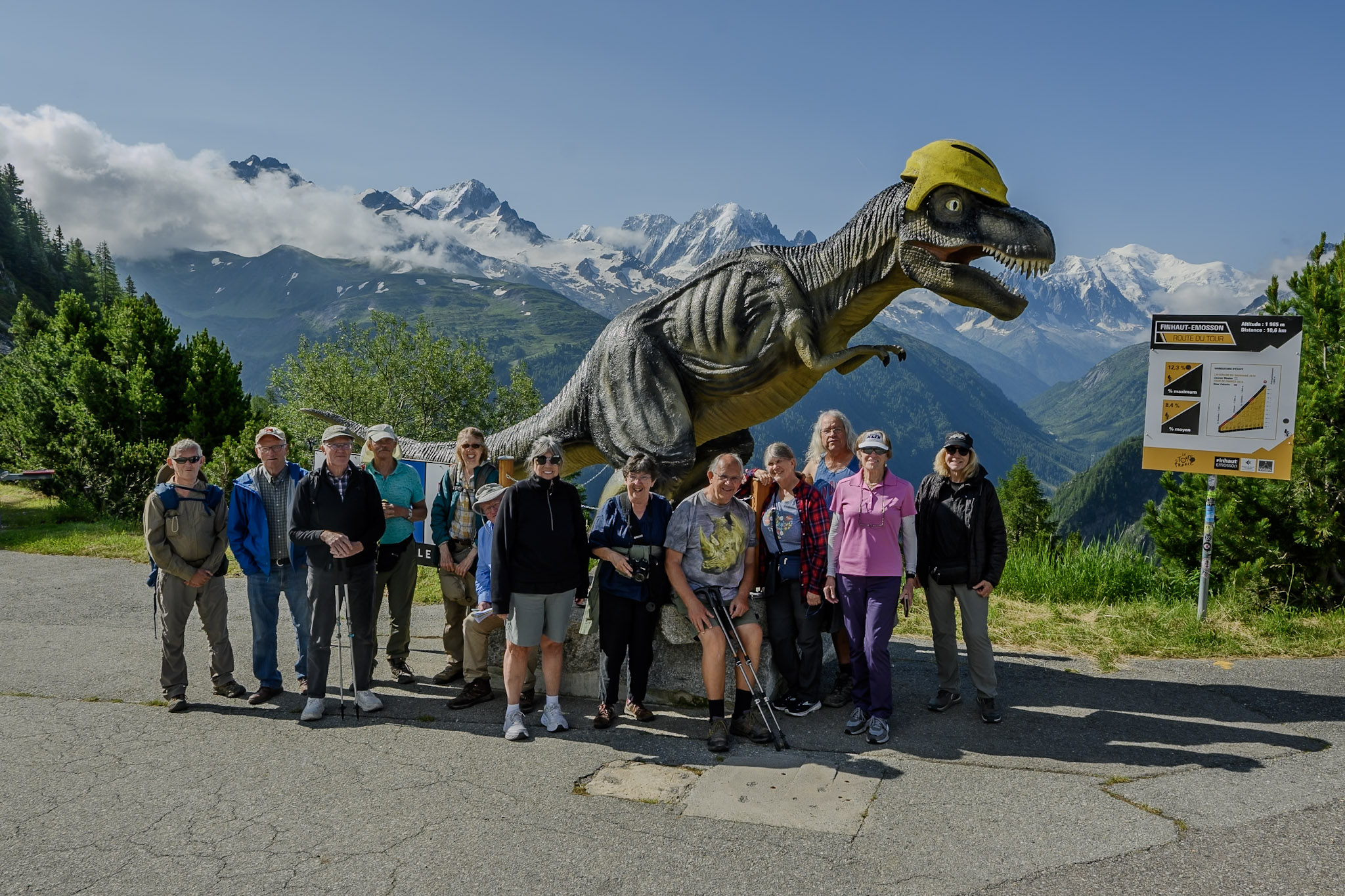
The GeoWorld Travel group in front of a dinosaur model wearing a cycle helmet at the Emosson Dam, with Mont Blanc in the background. Archosaur tracks (once thought to be dinosaur) have been found nearby. The Tour de France has also visited the site!
The group enjoys an explanation of the history and engineering of the Emosson Dam.
Andrew and Anne enjoying the view from the top of the Emosson Dam.
The GeoWorld Travel group on a guided tour inside the Emosson Dam.
Top left: The Gorges du Trient, which is 463m high at its maximum, was created by a subglacial river in the last ice age and cuts down into rock of the Mont Blanc massif. The gorge was further enlarged by glacial melt at the end of the ice age. Today, the gorge only contains a very small stream, because its water is being diverted into the Emosson reservoir.
Top right: Château de Chillon which is built on the island of Chillon, an oval limestone rock advancing in Lake Geneva between Montreux and Villeneuve. It has a steep side on one side and, on the other side, the lake and its steep bottom.
Bottom left: The group at the final stop of the tour: The Lavaux Vineyard Terraces UNESCO World Heritage Site on the shore of Lake Geneva.
Bottom right: The GeoWorld Travel group observing 20-million-year-old conglomerate Molasse sediments in The Lavaux Vineyard Terraces UNESCO World Heritage Site.
Day Ten: Geneva (departure)
After a fantastic tour of the wonderful geology of Switzerland, the group disperse – with some travelling on within Switzerland and Europe, and others returning home.
We will be returning to Switzerland again in the future. To find out about the latest dates and availability for the trip, please check out our website here: https://www.geoworldtravel.com/Switzerland.php


